The EPA's National Water Quality Inventory (NWQI) assesses the conditions of rivers, lakes, and estuaries every two years. The NWQI is mandated by the 1972 Clean Water Act and is the primary means for informing Congress and the public about the nation's general water quality conditions.
We have, however, omitted the NWQI data from this report due to concerns about the quality of the data. Data on water quality, unlike air-quality data which have been consistently measured, lack the measurement to enable evaluation of progress over time. To be sure, monitoring water quality is much more difficult and costly than monitoring air quality, but the measures currently used are seriously defective.
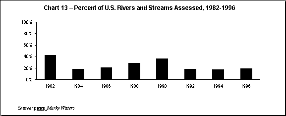
In 1992, the EPA admitted that the NWQI data "cannot be used to determine trends in national water quality or to compare water quality among individual States."28 The U.S. Geological Survey has been similarly critical, warning in 1991 that inconsistencies and methodological problems with the data "preclude any analysis of trends."29 The most serious limitation of the NWQI is that only a portion of our water bodies are evaluated, and the same points are not evaluated yearly. For example, in the 1996 NWQI, only 19 percent of the nation's 3.6 million miles of rivers and streams were evaluated, and only 40 percent of the 41 million lakes, ponds, and reservoirs were sampled (see Chart 13). NWQI data for estuaries were more complete, with 72 percent of the 39,000 miles of estuaries sampled.
The NWQI is not conducted by the federal government, but is in fact compiled by state agency reports. There is a wide variation in how thoroughly different states assess their water quality. Waters that some states deem "impaired," for example, would be found "non-impaired" by other states using a different method of evaluation. And, as we have observed in previous editions of this report, the combination of scarce resources and the bureaucratic incentive to locate the worst water conditions may lead to an overstatement of water quality problems. But in the absence of a more systematic monitoring and evaluation system, it is impossible to know.
The defects of the current approach to water quality monitoring were explored in detail in a May 1999 report released by Public Employees for Environmental Responsibility (PEER). The report, Murky Waters: Official Water Quality Reports Are All Wet, was produced by anonymous employees within the U.S. Environmental Protection Agency (EPA), as well as by current and former employees within select state environment agencies. It provides an insider's account of how the EPA's system of monitoring and assessing water quality has broken down.
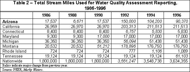
PEER charges that states have no incentive to deliver accurate reports or to achieve comparability whereby the water quality records of states can be meaningfully compared with each other or tracked consistently on a year-to-year basis. In order to make a valid assessment of water quality in each state, rivers and streams must be consistently counted and sampled every year. However, as Table 2 shows, the EPA and the states are not sure how many miles of rivers and streams they have.
For example, in 1990, Arizona claimed to have 17,537 stream miles. Two years later that number jumped to 150,000. In California, the same phenomenon can be observed. In 1990, California reported that it had 26,970 stream miles. By 1992, this figure jumped to 203,313 miles. The reason for these sudden jumps is that the EPA implemented a new method of determining total stream miles.
Other changes were implemented during the 27 years that states and the EPA were collecting data. In 1988, the EPA issued a guidance document suggesting that states could count hundreds of miles of rivers and streams as a single water body with a single assessment based on as little as one sample.30 PEER's report cites the example in Washington State, where one of the rivers was identified as being more than 3,900 miles long with no monitoring data ever associated with it. The EPA's guidance document caused the number of stream miles to substantially increase, but the number of rivers assessed went down by as much as 60 percent from 1982 to 1996.31
The most significant change the EPA made was to the 305(b) reports the states have to submit every two years to the EPA. The change allowed for a new way to report water quality. The new category, called "evaluated waters," was added to the category of "monitored waters" on which states should have already been reporting. The new category made it appear as if states were assessing more streams and rivers.The EPA wrote to the states that "it is expected that states will strive to increase the number of waters that they assess by tapping new data sources, including 'evaluated' waters in their assessments...."32 The result was, once again, a large increase in assessed miles with a corresponding decrease in the quality of that assessment.
The United States has spent nearly $600 billion on water quality improvement since 1970, and doubtless this has achieved substantial reductions in water pollution, especially "point source" pollution such as wastewater treatment plants and effluents from industrial facilities. But without a consistent monitoring system, evaluating past policy and creating new strategies must be done behind a veil of ignorance. The problem of systematic monitoring and assessment is especially acute with "non-point" sources of water pollution (i.e., stormwater and agricultural runoff) that may be more serious than point sources. A more thorough and consistent method of water quality monitoring needs to be developed in order to guide policy and prevent taxpayers and private citizens from wasting billions of dollars on the wrong measures.