Every five years the U.S Department of Agriculture produces the National Resources Inventory (NRI), which surveys land uses and conditions on non-federal lands. The chief purpose of the NRI is to evaluate soil conditions and monitor soil erosion, but the process of sampling more than 800,000 locations, mostly in rural areas, yields considerable ancillary data.
A summary (but not the complete data) of the most recent NRI was released in November 1999, and it generated considerable public attention because of its finding that the rate of urbanization has doubled over the last five years. Between 1988 and 1992, according to NRI figures, 7.3 million acres of land in the United States were developed, while between 1993 and 1997, 15.9 million acres, over 3 million a year, were developed. These findings have provided fresh fuel for the controversy over urban sprawl.
"These new figures confirm," Vice President Al Gore said when releasing the NRI, "what communities across America already know. Too much of our precious open space is being gobbled up by sprawl."
There is little doubt that the unprecedented prosperity of the 1990s has led to an increase in land development, but there is good reason to question whether the NRI figures are accurate. Changes of this magnitude over such a short period of time—in any category of economic activity—are highly unusual absent some extraordinary factor. Until the detailed state-by-state data are released, it will be impossible to conduct a thorough analysis. A number of observations and anomalies, however, can be noted from the NRI summary.
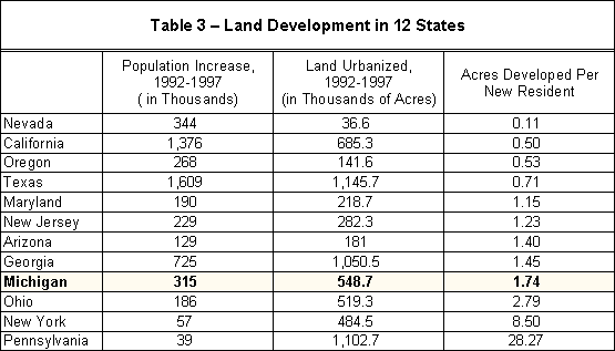
The NRI itself cautions that, "Statistics derived from the NRI database are estimates and not absolutes. This means that there is some amount of uncertainty in any result obtained using NRI data." That the degree of uncertainty may be very large is suggested by comparing some of the specific land development figures in the NRI with other sets of data. For example, one of the eye-popping findings of the NRI is that Pennsylvania, one of the slowest growing states in the nation, developed as much land (over 1.1 million acres) as fast-growing Texas and Georgia.
One way of understanding the difficulty with these figures is to compare the NRI land-development estimates with population growth, which is done in Table 3. From this, a simple ratio of the land developed per new resident of the state can be calculated. By this comparison, Pennsylvania developed at a rate of 28 acres for every new resident of the state, which is far out of line even with other slow-growing northeastern states such as New York and Ohio. Other anomalies can be observed in some of the fast-growing sunbelt states.
If the NRI figures are correct, California is developing its land quite efficiently, if efficiency is defined narrowly and simply as using the least amount of land per new resident, which is an inadequate definition. By these numbers, California is developing more "efficiently" than Texas, Georgia, Arizona, and even "smart growth" Maryland. Most startling of all, California used less land per person than Oregon, whose land-use planning policies are widely praised as the best in the nation. Nevada and Arizona present an especially striking anomaly.
Sprawl critics have been claiming that Las Vegas is being developed at a rate of two acres an hour. Yet the NRI reports a land-use rate for the whole state of Nevada less than half of that total. Nevada's population growth was nearly twice the population growth of neighboring, and fast-growing, Arizona, yet Arizona is reported to have developed four times as much land.
It should be kept in mind that ascertaining the amount of developed land is a secondary purpose of the NRI. Its primary purpose is to determine the amount and condition of various rural land resource categories, especially farmland. Most of its nearly 800,000 "sample points" are in farming and rural areas.
It is true that in states with modest population growth such as Pennsylvania, land development is driven less by population growth than by people leaving cities and "spreading out" in the suburbs. Nearly half of Pennsylvania's counties, including the counties where Philadelphia and Pittsburgh are located, are losing population, while ex-urban counties are growing at a rate much faster than the state as a whole, so the simple ratio of land to population growth in Table 3 does not settle the question.
A way of cross-checking the NRI figures, and generating an independent estimate of land development, is to compare other data on development activity that has actually taken place.
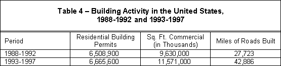
Table 4 shows the number of single- and multi-family building permits for the two five-year periods (1988-1992 and 1993-1997), along with the square feet of commercial construction, including schools and other public buildings, and the miles of roads built. As can be seen from these figures, there was not a doubling of building activity between the two periods.
Tables 5 and 6 convert these figures into acreage estimates for the amount of land developed. This technique finds that 5.5 million acres of land were developed from 1988-1992, while the NRI for those years estimated that 7.3 million acres had been developed. The difference between these two estimates is 1.8 million acres, about 33 percent. The NRI figure may well be correct; estimating land development from permits and other data sets would not capture parks and planned open space within housing and other kinds of development. Not all development is contiguous, meaning that open space between development would be considered "developed" in NRI statistics even if it is bare land.
From 1993 to 1998, this technique yields an estimate of 6.1 million acres developed—a 600,000 acre increase from the previous five-year period, or more than 100,000 acres a year—versus the NRI estimate of 15.9 million acres developed. The variance between these estimates is a staggering 9.7 million acres—a 158 percent difference. It does not seem plausible that this large difference could be accounted for through non-contiguous development or other open space that would be counted as "developed" land.
A large error in the NRI estimate for the amount of land developed is not unprecedented. In 1981, the Department of Agriculture's Soil Conservation Service (SCS) estimated that three million acres a year were being developed, the same rate as is now reported in the NRI. But the SCS had to withdraw that estimate by 1984 when the persistent inquiries of various scholars concluded that the SCS had overestimated development by a factor of three. A repeat of this episode may be on the way when the final 1997 NRI data is released for review.
Regardless of whether and how much the NRI estimates for the rate of land development are revised, the figures need to be put in a larger perspective. The NRI estimates that urbanized land now accounts for 105.4 million acres of land. This represents about 5.6 percent of the total land area in the continental United States (i.e., excluding Alaska and Hawaii). Most western states, where "sprawl" is said to be most rapidly occurring, are typically much less than 5 percent developed (Arizona and Nevada are only about 1 percent developed, while Utah is less than 2 percent developed) because of the large desert, mountain, and range areas in these states. Older, eastern states with more population typically have a higher proportion of their land classified as developed. Charts 19 and 20 show the proportion of various land uses in the United States and in Michigan, respectively.