Government officials and environmental activists use "stopping urban sprawl" as a mantra to support greater government control over private land use decisions in Michigan through central planning aimed at farmland preservation and urban revitalization. This study critically examines suburbanization and land use in Michigan to determine that the state's economy and farmland and citizens' quality of life are not threatened by economic growth and development, or what activists have dubbed "sprawl." The study argues that restrictions on suburban growth do not address the causes of why people move out of inner cities any more than the Berlin Wall addressed the problems of East Germany's repressive socialist economy. The study concludes by recommending a market-based approach to land use policy and identifying "urban sprawl" as the natural evolution of free people pursuing peaceful ends and their shot at the American Dream.
The battle cry is sounding across the forests, hills, strip malls, and subdivisions of Michigan: "We must stop urban sprawl!" Sounds good. But what is "urban sprawl?"
Local and state government officials and environmental activists use the term to create images of disorder, chaos, and irrational decision making about land use by Michigan’s private landowners. These officials and activists have adopted "stopping sprawl" as their mantra to support more government control over land use decisions through central planning and policies aimed at farmland preservation.
Derogatory references to "urban sprawl" are now part of the popular debate over land use issues, but amazingly, no one has ever bothered to clearly define what is meant by "sprawl." Often, the term is indiscriminately applied toward any form of suburbanization and "urban sprawl" has thus become an "I know it when I see it" issue.
This study critically examines suburbanization and land use in Michigan and determines that the state’s economy and citizens’ quality of life are not threatened by "sprawl."
The study analyzes five key issues: general land use trends, farmland preservation, economic development’s impact on the cost of government services, big city revitalization, and development’s effects on the environment. Data from the U. S. Department of Agriculture, the Michigan Agricultural Statistics Service, the U. S. Bureau of the Census, and other sources are analyzed to find the following:
1. Urbanization does not claim substantial amounts of land statewide. Although Michigan ranks 11th nationally in its degree of urbanization, only 9.8% of its territory is urbanized. Nationally, less than 5.0% of all land is urbanized.
2. Urbanization is not threatening Michigan’s agricultural industry. Farmland loss has moderated in recent decades, falling from a 17.0% loss rate in the 1960s to just 2.8% in the 1990s. At the loss rates of the 1960s, Michigan would run out of farmland in 47 years. But at current rates — even if farmland loss does not further moderate — Michigan has hundreds of years’ worth of farmland remaining. In addition,
Urbanization accounts for less than one-fourth of the acres taken out of farming;
Most farmland loss can be attributed to the creation of urban parks, reversion to forest, or other non-urban uses;
Public Act 116, an existing Michigan tax credit program, currently protects 41% of the state’s farmland from short-term development.
Meanwhile, Michigan’s agricultural output has remained stable in the 1990s and world and U. S. food output has increased dramatically since 1980.
3. The negative effects of development on local infrastructure costs are exaggerated. Previous studies did not accurately account for the costs and benefits of suburban development. While revenues from farmland appear to offset government costs, they actually account for less than 2% of local budgets. Residential development appears to drain local government services, but this "negative" impact is the result of erroneous fiscal calculations based on the inclusion of local school costs, which are actually absorbed by general local government revenues.
Even if land use policy forced housing onto smaller lots to conserve land, the statewide impact on land use trends would be minor. Urban land development would fall from 12.4% to 11.8% over the next 25 years and farmland loss would fall from 2.8% to 2.6%.
4. Factors such as crime, poor schools, and high taxes drive people from cities. People often migrate from central cities to suburban and rural communities due to cities’ poor schools, high crime and tax rates, and burdensome regulations. Until cities resolve these factors that "push" residents out, retaining urban populations will be difficult.
5. Higher residential densities may increase pollution levels. Higher density residential areas are associated with higher levels of air pollution, suggesting that the suburbanization of people and employment can mitigate pollution problems by decentralizing large cities.
Over the next 13 years, Michigan’s economy is expected to grow by 17.8%, personal income by 12.4%, employment by 9.0%, and population by 5.1%. More people than ever will be living, working, and playing in Michigan and state policy must therefore accommodate growth rather than prohibit it. This necessitates adopting market-oriented solutions to urban land use issues. Michigan policy makers should craft a policy that
Adopts an economically neutral stance that does not favor one industry over another;
Supports full-cost pricing for public services to ensure that local governments do not
subsidize land development;
Pursues voluntary and flexible approaches to land preservation such as tax credits;
Strengthens private property rights to facilitate markets, protect citizens’
freedom, and ensure the smooth transition among land uses; and
Facilitates rather than impedes community change and acknowledges that markets effectively match land uses and housing opportunities to the preferences of Michigan residents.
"Urban sprawl" is not a monster to be tamed; it is the natural evolution of free people pursuing peaceful ends and their shot at the American Dream.
"Sprawl is a plague on the land."[1]
"People are looking at . . . ways to tame the monster called suburban sprawl."[2]
"From planning experts to community leaders to farmers, people in Michigan are alarmed at how fast sprawl is gobbling up open land."[3]
"As bulldozers plow their way through more farmland in southeast Michigan . . . agriculturalists, environmentalists and homeowners are trying to find new ways to stop suburban sprawl."[4]
These are just a few of the reactions from politicians and the press to the economic development occurring in rural and suburban areas of Michigan. Many critics of growth use the term "sprawl" to conjure up apocalyptic images of disorder, chaos, and irrational decision making about land use by Michigan’s private landowners.
But there is another side to this debate. Suburbanization represents the creation of new communities and the transformation of old ones: The farming community gives way to the rural-residential community; the rural-residential community gives way to a full-fledged suburb; the suburb may even give way to a larger, economically and socially diverse city. This transformation of community inevitably means that people, jobs, and commerce shift with it.
Development results from the entrepreneurial use and re-use of basic economic resources — land, labor, and capital — to enhance the quality of life and standard of living of people. This process, even when it manifests itself in low-density housing, is not new. People have been suburbanizing at least since the 13th century, when they fled the diseases and unsanitary conditions of the city.[5] Suburbanization was, in a sense, the product of the first environmental movement: by moving out of large central cities, people moved to a healthier living environment. In the U. S., this decentralization has manifested itself as low-density residential, commercial, and industrial development.
What sets the modern era of suburbanization apart from historical trends is how these economic and population shifts occur. The advent of the automobile, cheap gasoline, and an interstate highway system ushered in an unprecedented period of personal mobility. Transportation costs plummeted, making it easier for people to live further away from an urban core. When these factors were combined with rising family incomes and cheap (subsidized) mortgage lending, the demand for suburban housing increased dramatically. The average working family could now afford, like managers and business owners before them, larger homes on separate lots. This also allowed people to move to smaller communities where government was closer to home. With the decentralization of jobs and the growth of suburban cities, an era of truly competitive local government was born.
This new era of suburbanization and decentralization created new tensions and conflicts: Farmers now fight new neighbors, often commuters who object to the routine of farm life (e.g., smells, noise, etc.); native residents used to traditional agricultural lifestyles now wrestle with the values of bedroom communities; environmentalists organize to stop new development that threatens wildlife, forests, and pastures — the list seems endless. In Michigan as in other states, the debate has escalated to the point where suburbanization is no longer a local issue. It has captured the ears of state policy makers and elected officials.
The proper policy response is still largely a matter of public debate. The record of other states shows a multitude of options. Oregon and Florida opted for top-down, centralized regional planning where population densities and development patterns were guided by state goals. Georgia implemented a statewide system of growth management that focused decision making at the local level, making state goals subordinate to local control. Maryland recently enacted a "smart growth" plan that avoids top-down planning in favor of a more market-friendly, incentive-based approach to land development.
In which direction should Michigan go? This study assesses the state of suburbanization in Michigan, evaluates its consequences for residents and citizens, and offers policy recommendations for state and local public officials to constructively address this question.
What is urban sprawl? This is probably the most important question facing Michigan policy makers, since the answer determines what kinds of issues should be addressed and what types of policies should be pursued.
Many people characterize sprawl loosely as unordered or chaotic suburban development. Webster’s dictionary defines sprawl as "to spread or develop irregularly."[6] Ecologist Holly Madill recently editorialized that urban sprawl is "to spread or develop characteristics of a city irregularly or carelessly."[7] On the surface, this definition is appealing, particularly if one relies on casual impressions of new, large-scale housing subdivisions, malls, and business parks.
But land development, even low-density suburban development, is not haphazard, random, careless, or even irregular. Real estate markets coordinate thousands of consumer and producer decisions each day and signal important information about cost and revenues through real estate prices. The logic of the market works this way: Property owners, such as farmers, sell their land to developers. Developers buy the land because they believe it has higher value for alternative uses, such as homes, office buildings, or shopping malls. Developers improve the property or sell it to businesses and families who are willing to pay the price and develop the land themselves. This is a rational process and is implicit in every market, from food to automobiles.
Indeed, markets create order out of seemingly random decisions every day by matching consumer preferences with products and services supplied by entrepreneurs and producers. These decisions are coordinated through the price system, and substantial empirical evidence supports the role of markets in this function.[8] Markets thus transform land from one use to another using the price system to guide buyers and sellers.
In market economies, the social value of goods, services, and resources are reflected in prices. These values are a product of the choices people and families make about what goods and services they want to buy. This is a dynamic process: Decisions about which land to buy, which land to sell, and at what price, are based on expectations. No one guarantees that these expectations will be met by consumers or producers. Entrepreneurs face uncertainty and risk. Their reward for correctly assessing consumer needs will be profit, provided they produce the goods and services efficiently. Entrepreneurs fail if they incorrectly assess the state of the market. Land developers face these constraints and potential rewards every day, just like other businesses.
Property rights are central to the efficient functioning of land markets and to ensuring that all economic resources — including land — are put to the highest and best use. Private property rights are traditionally viewed as a fundamental building block for civil and political liberty, but they are also critical for providing economic opportunity and encouraging innovation. The protection of property rights allows people to buy and sell products and services, such as farmland and personal labor, to the highest bidder. It preserves liberty by ensuring that resources are bought and sold as a result of voluntary, individual choice rather than arbitrary and unfair government coercion. |
Urban planners have attempted to define sprawl more precisely (see Appendix A on page 55), but, ultimately, "urban sprawl" ends up as an "I know it when I see it" issue. This is problematic from the perspective of public policy. Without an understanding of what sprawl is, a clear policy response cannot be developed. Based on the tenor and substance of the public debate in Michigan, urban sprawl seems to be defined by three major trends and concerns:
The suburbanization of people and out-migration from big cities such as Detroit, Grand Rapids, Ann Arbor, and others;
The loss of farmland and open space; and
The apparent government service costs associated with providing infrastructure for low-density residential and commercial development.
This concept of sprawl is clearly broad. It can include most suburbanization. Yet it is probably closest to what most Michigan residents consider to be "sprawl," and it reflects the factors that have driven current state, regional, and local policy discussions.[9]
Many Michigan residents may be concerned about suburbanization mainly because of its high visibility. Concerns about the rapid development of land — and the widely reported decline in farmland — are directly tied to things people see every day. Residents observe the manifestation of suburbanization every time they drive to work or go shopping because most people live in a relatively concentrated part of the state. Almost 10 million people live in Michigan, and 82.5% of them live in urban, or "central city," and suburban, or "collar," counties (see Appendix B on page 57)[10]. The urbanized portions of these counties occupy about 10% of Michigan’s land.[11]
Michigan’s collar counties — suburban counties that surround central city counties — are the fastest growing in the state, adding 346,074 people, or 10.3%, between 1980 and 1995 (Chart 1). Rural counties also grew quickly, at 8.3% from 1980 to 1995, adding 127,718 people. These people, however, were spread out over more than half the state. Meanwhile, central city counties — those counties with a large identifiable urban core, such as Detroit or Kalamazoo — experienced a loss of 4.3%, or 186,417 people. People are leaving the most heavily populated counties in Michigan and moving to less populated, but nearby, counties. These collar counties were clearly the largest beneficiaries of new population growth and out-migration from central city counties.[12]
Despite this out-migration, most of Michigan’s urbanized counties still have a rural character and feel. Overall, Michigan contains 37.4 million acres of land. The state’s metropolitan areas[13] include 10.4 million acres, or 27.8% of the total land area. Within these metropolitan areas, almost two-thirds of the land is not urban (see box on page 9).
At first glance, this is an odd result. More development means that more land is converted to urban uses. The outcome is nevertheless consistent with the way counties are grouped by the Census Bureau into metropolitan areas. Most counties in Michigan have substantial tracts of open space, pasture, and farmland. Even Wayne County, home to Detroit and the most densely populated area of the state, still has 17% of its land in forest, cropland, water, or pasture.[14]
Overall, 22.7% of Michigan’s land is devoted to uses other than farmland, forest, and water such as urban uses, parks, golf courses, and roads.[15]
|
Defining Urban Uses The Michigan Agricultural Statistics Service (MASS) does not classify land in the same way as the U. S. Census Bureau. The MASS definition is much broader, consisting of a "residual" category. In other words, any land that cannot be classified as forest, pasture, cropland, or water is dumped into the category of "other."[16] Thus, "other" includes urbanized land, land devoted to transportation uses (e.g., roads and highways), wasteland, and anything else that cannot be easily classified. This category also includes land used for residential purposes but not in cities, villages, or other urban areas. In contrast, the U. S. Department of Agriculture relies on a methodology developed by the U. S. Census Bureau. The Census Bureau defines an area as "urban" if it meets certain density and population criteria. For example, an urbanized area must have a population of at least 2,500 people and adjacent areas must have a population density of 1,000 people per square mile,[17] or 1.56 people per acre. Thus, a family of four occupying a 2.5-acre parcel of land could be included in an urbanized area while a family of four on a 5-acre parcel of land might not (depending on the proximity of other households and land uses). The remainder of this study will refer to the "other" category as "urban" while, in fact, "other" is much more inclusive. Thus, the analysis will be overstating the actual amount of urban land in Michigan counties, an unfortunate side effect of the imprecise way the data are gathered and classified.[18] |
Not surprisingly, central city counties have the highest proportion of land in non-rural uses. These counties, however, only devote 44.3% of their land to these uses, while collar counties have 38.9% dedicated to urban, transportation, waste and "other" uses. Rural counties only have 17.0% of their land devoted to other non-rural uses. Thus, with the exception of Wayne County and others close to Detroit, even the most urbanized counties in Michigan are still largely rural.
|
Big Cities Occupy Little Land but House Most People Saginaw County illustrates how even metropolitan areas can be rural in character despite the existence of large urbanized areas. More than half of Saginaw County’s land (55.7%) is devoted to cropland, 23.8% to "other" uses (including urban uses), 18.9% to forest, 0.8% to water, and 0.7% to pasture.[19] The city of Saginaw consisted of 11,136 acres (17.4 square miles) in 1990, or 2.1% of Saginaw County’s land area. Despite occupying such a small portion of the county’s land area, the city of Saginaw housed 32.9% of the county’s population. Land use patterns in other central city counties are similar. High-density cities house most of the region’s population but occupy very small portions of the metropolitan area’s land base. Ann Arbor, for example, houses 38.7% of Washtenaw County’s population on just 3.6% of its land area. One third of Washtenaw County’s land use was devoted to cropland and 17.8% to forest in 1992. Kalamazoo houses 35.9% of its county’s population on just 4.2% of its land area. More than half of Kalamazoo County’s land area, 53.9%, was devoted to cropland and forest use in 1992. This is consistent with national data. Three quarters of the U.S. population live in urban areas that make up less than 3.5% of the nation’s land area.[20] |
In fact, Michigan counties are rural, except for those in the Detroit area (see Chart 2). As host to Detroit, Michigan’s most populous city, Wayne County devotes 83% of its land to "other" uses, including urban uses. But the urbanized portion of counties in the Detroit metropolitan area tapers off fairly quickly. While neighboring Oakland County devotes more than half of its land to nonagricultural uses, cropland and forest uses still make up 29.7% of all land use. Cropland and forest uses make up 40.2% of all land uses in Macomb County, 63.5% in Lapeer County, 66.7% in Monroe County, and 50.1% in St. Clair County. Thus, even some of the densest, most populous counties in the state contain substantial portions of undeveloped land.
Overall, about 89% of Michigan’s land area is devoted to exclusively rural uses or exists in rural counties, according to data provided by the Michigan Agricultural Statistics Service (MASS). Thus, despite recent concerns about loss of farmland and rapid land development, Michigan remains a predominantly rural state.
Counties closest to population and employment centers will experience higher levels of land development. Thus, the transition from agricultural uses to suburban and urban uses is very visible and, as in all social transformations, often becomes a source of conflict in local communities.
As Michigan residents have moved to rural and suburban counties, densities have also increased (see Chart 3). In 1970, suburban counties averaged 2.3 acres per person. By 1995, suburban counties averaged 1.85 acres per person, a 19.6% decrease. Statewide, the number of acres per person fell just 7% to 4.13 acres per person. This suggests that increased population growth is also changing the attitudes and "feel" of some rural communities. As cities grow and more residents commute outside their city of residence to work, the rural atmosphere gives way to the concerns of family-oriented suburbanites. These increasing densities imply a diversification of the local economy as residential and commercial uses become more prevalent in the local real estate market and economy.
These shifts in population reveal another important aspect of the politics and economics of growth in Michigan. Big city counties — such as Calhoun, Genesee, Ingham, and Wayne — lost population, reducing their overall density. A further look inside these counties reveals that a substantial portion of the population loss occurred in the big cities themselves.
Some analysts have interpreted the growth of suburban areas as the result of a "beggar-thy-neighbor" effect where one suburb’s growth is a function of the central city’s decline. However, this is not necessarily the case. While central city counties lost population, the data also show that surrounding collar counties added more people than their more populous neighbors lost. But the problems of central cities are far more complex than this criticism of suburbanization suggests. (Please see Part VI, "The Flight from the Big Cities," on page 35 for a discussion of the particular problems facing large Michigan cities such as Detroit.)
In the end, keeping people from moving away from the cities by restricting suburban growth will not address the issues that drive them out of the cities in the first place, any more than the Berlin Wall solved the problems of East Germany’s repressive socialist economy.
Many people believe that suburbanization in Michigan increased dramatically in the 1980s. Part of the reason for this belief is that farmland loss data are typically only reported for recent decades rather than through long-term historical trends. For example, Governor Engler’s task force on farmland preservation popularized the term "10 acres an hour" as a rallying cry for constraining suburban development by citing data from 1982 to 1992.[21]
While the task force’s report mentioned that the period of the fastest decline in farmland was between 1954 to 1974, it failed to show that the rate of farmland loss has declined steadily since then and that urban land development may account for less than one-third of this decline. A more critical analysis of state and national land use trends suggests that suburbanization and farmland loss are, in fact, moderating. Thus, historical loss rates may be misleading unless they account for moderating influences and the dynamics of land markets.
Nationally, the most rapid rate of suburbanization occurred between 1920 and 1950.[22] A national study of more than three hundred fast-growth rural counties in the 1970s and 1980s — those on the fringe of development and most symbolic of sprawl — found land use trends moderating. These moderating trends are likely to continue as national population growth also continues to moderate. "The net effect of changing household number [size], household characteristics, and economic constraints on demand for land," note economists Marlow Vesterby and Ralph Heimlich, "is likely to mean less conversion of land for urban uses in the future."[23]
Where does Michigan "stack up" against other states? Nationally, 4.8% of the United States’ total land area is urbanized, including federally owned lands as defined by the U. S. Department of Agriculture.[24] The median — the proportion of land urbanized in the state that is the midpoint of all states ranked by their degree of urbanization — is just 5.2%. The most urbanized states are in New England: New Jersey, Rhode Island, Massachusetts, and Connecticut each have about 25% or more of their land area urbanized. New Jersey is the most urbanized state with more than 30% of its land area urbanized. Thus, despite centuries of urbanization, no state in the U. S. has more than half its land developed for urban uses. More than three quarters have over 90% of their land in rural areas (see Chart 4 ).
Michigan ranks 11th out of 50 states, with 9.8% of its land rated as "urban." At first glance, Michigan’s ranking relative to other states might be alarming. Yet, 9.8% of urbanized land implies that 90.2% is non-urban. Michigan is less urbanized than North Carolina, Maryland, and Pennsylvania and as urbanized as New York, New Hampshire, and South Carolina.
If Michigan were to double the proportion of its land currently in urban areas, 19.6% would be urbanized. Thus, more than three quarters of Michigan’s landscape would still be rural in character. In fact, despite the historically rapid increase in urbanization, the rural character of Michigan is unlikely to change based on long-term trends in farmland, forests, and urban areas (see Chart 5). The national data confirm that Michigan, like the vast majority of states, is largely rural.[25] State land use trends suggest this rural character will be maintained well into the future.
|
Michigan Statistics Overestimate Urbanization The Michigan Agricultural Statistical Service (MASS) projects a slightly more alarming picture of urbanization because of its expansive definition of land uses "other" than rural or agricultural. Overall, 22.7% of Michigan’s land falls into this "other" category.[26] Even using this data, however, the rural character of Michigan is evident. Most counties report less than one-third of their land is devoted to urban and transportation uses. A few counties are highly urbanized, most notably Detroit’s Wayne County, suburban Detroit’s Oakland and Macomb Counties, and Flint’s Genesee County (53.4%). All other counties have less than half of their land devoted to urbanized uses, including Ann Arbor’s Washtenaw County, Grand Rapids’ Kent County (41.3%), Kalamazoo County (41.3%) and Lansing’s Ingham County (35.7%). The county data suggest that urbanization is concentrated largely in built-up areas of the state. Concerns over urbanization and loss of farmland due to suburbanization will be concentrated in those counties on the verge of "tipping" from primarily agricultural uses to suburban and commercial uses. Not surprisingly, these counties include Washtenaw, Kent, Kalamazoo, and Ingham. For counties such as Wayne and Oakland, which have apparently already made the transition, concerns are more likely to revolve around central city and inner-suburb decline. |
The national and statewide data, then, suggest that suburbanization and low-density development have not seriously jeopardized the rural character of Michigan. Nevertheless, concerns about the impact of suburbanization on the state’s agricultural sector have persisted, particularly since some analysts have claimed that new development has displaced some of Michigan’s most productive farmland. The next section evaluates this concern more fully.
Concerns about the loss of farmland drive much of the sprawl debate in Michigan. As people move away from densely populated central cities, houses are built to accommodate them in formerly rural areas. Many have argued that this new development is displacing some of Michigan’s most productive farmland.
For many people, the loss of farmland is best illustrated by the loss of farms. The number of farms in Michigan fell from over 203,261 in 1900 to just 52,000 in 1997, a 74.4% drop.[27] The largest reduction in farms occurred between 1940 and 1970, the period preceding current farmland preservation efforts, when Michigan lost 106,000 farms. From 1980 to 1990, Michigan lost another 11,000 farms, and another 2,000 farms from 1990 to 1997.[28]
The general decline in the number of farms is consistent with trends in the amount of land in farms. More than 19 million acres were in farms in 1920 (see Chart 6). By 1970, total acreage in farmland had fallen by one third to 12.7 million acres.
More recently, farmland loss has moderated. In 1989, Michigan had about 10.9 million acres in farms. By 1997, the number of acres in farms fell to 10.5 million, a decline of just 3.7%. This is one-fifth the loss rate of the 1960s and almost one-third the rate of the 1970s.
Projections of future farmland losses based on historical patterns are unreliable. For example, Michigan had 12.7 million acres in farmland in 1970. During the 1960s, the state lost 2.7 million acres in farmland. If this acreage loss had been sustained at this same pace, Michigan would run out of farmland within 50 years.[29] In the 1970s, farmland loss moderated to 1.3 million acres over the course of the decade: At this pace, Michigan would run out of farmland within 100 years. Now, at 1990s acreage loss rates, Michigan has more than two centuries of farmland left. Ironically, farmland loss was moderating even during periods when newspaper headlines highlighted urban sprawl and the Governor’s agricultural task force recommended legislative action to protect farmland from economic development.
The moderation in farmland acreage losses is even more clearly evident when the rates of farmland loss are compared. During the 1960s, Michigan lost 17.5% of its farmland. At the same rate of farmland loss — land conversion to non-farm uses at 17.5% per decade — the state would have fewer than 2 million acres left in the year 2070 (See Chart 7). Using the most recent trends from the 1990s, Michigan would lose less than 3% of its farmland each decade. If this more moderate rate is more accurate, Michigan would not be in serious danger of losing significant amounts of farmland for a very long time.
Furthermore, these projections and estimates ignore the fact that other land — forest, pasture, and even urbanized land — can be converted to farmland and harvested for crops. The latter point is particularly important because the conventional wisdom holds that urbanization is the primary culprit in reducing the amount of land in farms. The reality, however, is quite different.
Urbanized land area increased by 194,000 acres in Michigan from 1982 to 1992,[30] a 12.4% increase. Land in farms, however, declined by 854,002 acres[31] (7.8%) during the same period. Even if all land converted to urban uses came from farmland (not used for parks, forests, or other recreational uses), urbanization would account for less than one-quarter (22.7%) of Michigan’s farmland loss. The remaining farmland loss — more than three-quarters of the total loss during the decade — must be related to non-urban causes. Some of the farmland, for example, may have been converted to parks or recreational uses or converted into forest.[32]
These trends are also consistent with patterns found nationally. In an analysis of 135 fast growth counties during the 1980s, urban land increased by 37.0% while agricultural land declined by only 2.4%.[33]
|
Tax Credit Program Already Puts 41% of Michigan Farmland Off-Limits to Development Even if Michigan farmland were disappearing at increasing rates, state legislators enacted a law in 1974 (Public Act 116) that already protects substantial amounts of farmland from development. The program, subsequently modified in 1996,[34] allows owners of farmland to restrict future development in exchange for tax credits. These "Farmland Development Rights Agreements" are negotiated between the property owner and the Michigan Department of Natural Resources. These agreements limit future development for at least ten years, and as much as 90 years. Forty-one percent of Michigan’s farmland, or 4.2 million acres, is currently enrolled in this program. |
|
The Loss of Prime and Unique Farmland Another concern raised by many activists is the loss of prime and unique farmland in Michigan. Prime farmland is highly productive as a result of irrigation, location, soil type, and a variety of other criteria. In Michigan, the amount of farmland that is prime is difficult to estimate. Most people believe prime farmland is currently located in the southern half of the state. "Land classified as prime farmland," notes the U. S. Department of Agriculture, "has the growing season, moisture supply, and soil quality needed to sustain high yields when treated and managed according to modern farming methods."[35] Nationally, 24% of rural non-federal land and half of all cropland is classified as prime.[36] About 28% of urbanization uses prime farmland.[37] One third of converted land is non-prime forestland and another 24% is non-prime farmland.[38] Designation as prime farmland, however, does not necessarily imply it is economically productive. Some of the nation’s most productive farmland is not "prime." "Florida and Arizona," the U. S. Department of Agriculture observed recently, "have little prime farmland . . . but these areas rank among the most economically productive in the Nation."[39] A number of important factors influence the productivity of agriculture, including weather, erosion, the use of fertilizers, pesticides, and other technologies. |
Concern about the loss of farmland is tied — often explicitly — to concerns about agricultural production. A recent Michigan State University study, for example, warned that "[Farmland acreage trends] should assure that Michigan citizens will have sufficient land for food production to the year 2010, but future generations may not be able to produce enough food if the population continues to grow."[40] An impending food shortage was implied when the authors added, "Farm products will continue to be exported from and imported into Michigan, but other states will also experience decreases in farmland and cropland acreages and face similar challenges to provide an adequate food supply."[41]
The need to cultivate additional land for food is unlikely, given recent trends of decreasing farmland loss, and Michigan’s agricultural output remains remarkably strong despite the loss of farmland (see Chart 8). Agricultural production has hovered steadily around 24 million tons since 1992.[42] While production dipped in 1996, this slump is likely to be temporary. In addition, only about two-thirds of Michigan’s farmland is harvested. The rest is laid fallow or left as open land. Thus, more land could be brought "on-line" to boost production, if needed. Even if agricultural production could not keep pace, Michigan could still trade products from its other major industries — such as automobiles — for food from other states who specialize in agricultural production (see box on page 21).
Despite the declining number of farms and lower employment, the industry has generated output worth about $2 billion each year since 1990.[43] In one year, 1995, the value of Michigan’s agricultural products generated revenues more than one-third higher than 1990 levels. Even though the value of agricultural production declined in 1996, total value still exceeded 1992 levels.
|
The Agricultural Industry in Michigan At first glance, stable revenues seem to describe a declining agricultural industry in Michigan. Total output and production numbers mask important changes in employment, income, and industry in the national and state economy. Farming and agricultural production, while important, are becoming relatively less significant economically. First, agricultural prices have fallen steadily over the years as new technology and changes in farming methods have dramatically boosted the supply of food. From 1990 to 1995, producer prices for all farm products fell 4.3%—7.7% for fruits, melons, vegetables, and nuts; 27.3% for fresh fruits and melons; and 19.7% for livestock.[44] Changes in prices are important signals to farmers about what to produce and what not to produce. Not surprisingly, cash receipts in each of these food categories where prices fell declined during this period. Cash receipts in corn, soybeans and vegetables increased, reflecting rising prices for these categories, but also incentives to produce food to meet demand. Agricultural production, like output in other sectors of the economy, adjusts according to the demand for products and expectations about profitability. Michigan’s agricultural industry is not unique in this respect. |
As noted above, even if Michigan’s agricultural industry were in decline, production in other parts of the nation would quickly take up the slack. The United States is a net exporter of food products, and numerous states could expand existing farm production to ensure Michigan citizens have enough food to feed themselves and the rest of the world.
World food production has increased steadily since 1980: Output for meats, rice, and fish has increased by more than one third (see Table 1, next page). From 1950 to 1992, worldwide grain production per person increased 154.5%.[45] These increases are largely a result of the ongoing technological revolution in agriculture.
Table 1 – World Food Production, 1980-1994 (in Millions of Metric Tons)
Production in |
% | ||
Product |
1980 | 1994 |
Increase |
Barley | 156.7 |
160.8 | 2.6% |
Corn | 397.5 |
470.4 | 18.3% |
Meats | 135.9 |
194.7 | 43.3% |
Rice | 398.9 |
534.7 | 34.0% |
Wheat | 440.1 |
564.1 | 28.2% |
Fish catches | 72.0 |
101.4 | 40.8% |
In the United States, the farm output index rose from 73 in 1970 to 92 in 1980 to 108 in 1993.[46] This is a 17.4% increase over 1980 output levels and a 47.9% increase over 1970 output levels. Moreover, the U. S. continues to be a net exporter of agricultural products[47] and total farm income increased by 63.0% from 1980 to 1994, according to the U. S. Bureau of Economic Analysis.[48]
The U. S. Department of Agriculture’s Economic Research Service concluded in a recent report that "losing farmland to urban uses does not threaten total cropland or the level of agricultural production which should be sufficient to meet food and fiber demand into the next century."[49]
In fact, higher yields and stocks have allowed a new industry to emerge. Corn and other crops are now used for industrial and other non-feed uses such as fuel alcohol and energy from biomass. Whether these uses create significant new demand for crops will depend on market factors such as the scarcity of other energy sources. "The use of cropland to produce biomass as a primary product will depend on returns to biomass crops exceeding the return to crops currently produced" notes the U. S. Department of Agriculture.[50]
Despite widespread concern over lost farmland, Michigan’s agricultural industry remains healthy. Michigan residents are not in danger of food shortages due to the loss of farmland in the state. More importantly, the loss of farmland has moderated in recent years.
Urban land comprises a small part of the state’s land use. Even if urban land increased dramatically, Michigan would remain a rural state with an abundance of forests and farms. The loss of agricultural land and open space appears to be concentrated in a few of the state’s fastest growing counties near major urban areas. This suggests that land use trends are, in fact, the result of an orderly process, not chaotic whims of farmers selling their land to developers. Land markets are converting land uses to meet the needs and preferences of Michigan citizens and residents.
Although "urban sprawl" is not "gobbling up" land at unprecedented rates, this does not imply that land development is always benign. Even if farmland preservation were not an issue, concerns over the costs of providing services to new residential and commercial subdivisions and the environmental impacts of development would be important issues that might justify state government attention. These issues are addressed in Part V through Part VII.
One of the more controversial aspects of land development is whether it "pays its way." Many people would have fewer concerns about suburban development if they believed tax revenues from new development covered the costs of providing services, particularly roads, sewers, water services, solid waste disposal, and schools.
The fear that new development may not pay its way is partly a function of how these services are provided. Since many services — including schools — are provided by local governments, they tend to be "priced" at their average cost. For example, when a local government considers extending a water line to a new home, it often bases its fee on a citywide average as opposed to the actual costs of extending the hook-up to that particular site or development.
In addition, the first developers must cover the full cost of extending the main trunk line to the new development based on established density guidelines or the zoning code, regardless of the number of units the developer plans to build. The initial capital costs may thus be imposed on the first property owner who wants to develop his or her property. This approach to infrastructure pricing tends to discourage "in-fill" — the development of vacant land in between already developed areas — and to instead encourage large subdivisions where developers do not subsidize later arrivals.[51]
Since publicly provided infrastructure services tend to use average cost pricing for new extensions, the potential for subsidizing new development exists. For example, a city might determine that the initial cost of tapping into the city’s sewer system averages $4,000 and assess that fee for every building unit, regardless of the individual building type. In some cases, the actual cost to the city might exceed $4,000 but the builder or developer will not be charged for the full costs, thereby subsidizing the development.
In contrast, marginal cost pricing is more typical among privately provided services. Prices for new water extensions are based on the cost of each new project rather than a citywide average. This means the marginal cost of extending the service is assessed against the user and capital costs and other costs such as debt are incorporated into the price of the service.
The fear that development does not pay its way has prompted some citizens’ groups and public officials to advocate and impose growth controls or otherwise limit new development.
Cost of Community Service (COCS) studies attempt to determine whether land development pays its own way in terms of public services. The American Farmland Trust promotes COCS studies as "an inexpensive, easy-to-understand way to determine the net fiscal contribution of different land uses to local budgets."[52] These studies are becoming more common because they are easy to use and apply; at least one has been conducted in Michigan.
COCS studies try to match services provided by local governments with the revenues generated through taxes tied to land use and land values. For example, an office building uses public services such as water, sewer, roads, and fire and police protection. These services are funded from the tax revenues and fees paid by the business.
COCS studies match land uses to tax revenues by first determining the pattern of land use in the local community. Often, this means determining how much land is devoted to a particular use, i.e., residential use, commercial use, and agricultural use. Then, the costs of providing public services are determined and allocated to each of these particular land use types based on their prevalence in the community.
The costs of the various public services are then compared to revenues generated through taxes that are a direct result of land development. For example, property taxes are included in the revenue calculation because they reflect changing land values due to development. A federal grant for a road improvement would not be figured into this revenue calculation because the grant money is not tied to property development. Similarly, user fees are not included because they are assumed to cover the marginal costs of the services and do not draw from general revenues. User fees, when set correctly, require users to "pay their way."
Despite the flaws and limitations of COCS studies (see box, below), dozens of them have been conducted across the country to determine whether various land uses "pay their way." Unfortunately, the results of these studies have often been used to justify growth controls, particularly on residential development:[53] Most COCS studies find that areas of residential development fail to generate sufficient tax revenues to cover the costs of providing them with public services.
Recently, the American Farmland Trust reviewed the results of 40 COCS studies in 11 states.[54] Twelve of these studies (30.0%) were performed by the American Farmland Trust and 11 (27.5%) were performed by the Southern New England Forest Consortium.
|
Limitations of Cost of Community Service Studies |
|
Several problems emerge if COCS studies are used to evaluate the cost effectiveness of different types of land development. These problems severely limit their applicability to developing and using realistic policy recommendations. Among the more important limitations are the following: |
|
For every dollar raised in revenue, according to these studies, farmland requires government expenditures of just 31 cents (see Chart 9).[55] Commercial and industrial property is even more cost-effective: 29 cents is spent on public services for every dollar raised in revenues.[56] Residential property, however, is a net drain on local governments. Residential property requires spending $1.11 for every dollar in revenues raised.[57]
Thus, while farm, forest and open lands generate more revenues than expenditures, COCS studies find that "residential land uses . . . are a net drain on municipal coffers: It costs local governments more to provide services to homeowners than residential landowners pay in property taxes."[58] More importantly, from the American Farmland Trust’s perspective, "In every community studied, farmland has generated a fiscal surplus to help offset the shortfall created by residential demand for public services."[59]
In Michigan, only one known but widely cited COCS study has been performed, focusing on Scio Township in Washtenaw County. Initially, the analysis was prepared as a graduate student research project in the School of Natural Resources and Environment at the University of Michigan.[60] The study was later published by the Potawatomi Land Trust.[61] Like the studies that served as its model, the University of Michigan study deconstructed local tax revenues and government expenditures based on land use.
The study found that for every local dollar raised in Scio Township, residential property required $1.40 in local government service expenditures.[62] Farmland, in contrast, raised enough revenue to offset public expenditures. Commercial and industrial land had the largest positive fiscal impact on the township: for every dollar raised in revenue, the township spent only 26 cents.
In addition to the standard limitations of COCS studies, the Scio Township analysis demonstrated additional flaws and weaknesses. The reader, for example, is left with the implication that agriculture (as well as commercial and industrial property) pays for itself and should be encouraged over other land uses, particularly residential land uses. In fact, based on this analysis, one could conclude that Scio Township should encourage agricultural development to balance the negative fiscal impacts of residential development.
However, agriculture represents only 1.4% of the township’s total revenues from general taxes on land uses (see Chart 10). Agriculture generated only $203,532 in revenue[63] while commercial and industrial property generated $5 million and residential property generated $9 million.
|
Farmland Revenues Are Small Compared to Commercial and Residential Uses Farmland does not produce the revenue per acre that either residential or commercial development does. Take the following possible scenario. Scio Township consists of 22,000 acres.[64] In 1985, 36.4% of Scio Township’s land was devoted to farming. This proportion has probably fallen although more recent estimates were not provided in the study. (Countywide, the amount of land in agricultural uses is about 41%.[65]) Suppose, hypothetically, agriculture now makes up 30% of the township’s land use (a 17.5% drop from 1985). This suggests that about 6,600 acres would still be used for farms. This also implies that agricultural uses generate about $30.84 per acre in revenues. If we assume all the remaining acreage is devoted to commercial, industrial, and residential uses, these land uses would generate on average at least $900 per acre.[66] If farmland produced the same revenue per acre as urbanized uses, Scio Township would need just 226 acres to generate the revenues currently derived from agricultural land. Clearly, the township cannot rely on agricultural land uses to generate significant revenues for local government services. |
If local policymakers were basing their land use policy on the tax and spending impacts estimated in the Scio Township COCS study, they would want to discourage residential development and encourage agricultural, commercial, and industrial uses. In addition, if land use decisions were made purely on net fiscal benefits, Scio Township should reserve all of its land for commercial and industrial uses. This would, of course, require extensive commuting by workers from other parts of the county or neighboring counties, which, in turn, would ironically encourage sprawl-like development patterns in neighboring townships and nearby counties.
Scio Township, like most communities, would want to encourage a mix of land uses. Local land use policy should be designed to facilitate the synergies among varied land uses, not impede them. Unfortunately, a COCS study provides little insight into how this would be achieved.
COCS studies also fail to shed light on the appropriateness of different types of residential development. The push to preserve farmland and limit residential development is driven in part by the belief that low-density residential development is inefficient compared to high-density residential development. This means that COCS studies must break the "residential land" category down further than the broad classification that is typically used. Because they often do not do this, COCS studies provide little useful information about the cost of public services in higher density land developments.
A final weakness of the Scio Township study was its approach to school funding and spending. School districts are independent governmental units and have independent taxing authority. District boundaries do not necessarily conform to township or municipal boundaries. As economist Gary Wolfram pointed out in his critique of the Scio Township COCS study, the authors’ inclusion of schools to assess the revenue impacts on township government was inappropriate.[67]
The implications of including education in the Scio Township analysis are significant. Excluding schools, residential land uses generated $1.7 million in revenue and incurred just $857,800 in expenditures. Its expenditure-to-revenue ratio was therefore calculated at 0.49, suggesting that the township’s residential land has a positive net fiscal impact. But when schools were included in the equation, the scales were tipped against residential development.
While the Scio Township study made adjustments for the statewide school finance reform brought about by Proposal A in 1994, it failed to recognize that education is provided through a different government authority with independent financing and provision requirements. The state of Michigan, rather than local school districts, is now the primary financier of public education, changing significantly the cost and revenue environment in which schools operate. The failure to consider this fact skewed the study’s findings.
The Southeast Michigan Council of Governments (SEMCOG) has provided a more compelling — though also flawed — argument for land use restrictions. In June 1997, SEMCOG released a report arguing that current development patterns were inefficient. The study, Fiscal Impacts of Alternative Land Development Patterns in Michigan,[68] proposed "compact development" as an alternative to current trends.
The SEMCOG researchers identified 18 communities for detailed analysis based on projections for population and employment growth during the 25-year period between 1995 and 2020. The communities ranged in size from 65,978 (Canton Township in Wayne County) to 2,262 (Montague in Muskegon County).[69]
Using an approach pioneered by researchers at Rutgers University, the SEMCOG study asked a simple question: How would infrastructure and land costs be affected by redirecting housing units onto smaller lots and clustering them closer together? The study’s authors hypothesized that this "compact development" pattern — putting houses closer together on smaller lots near cities — could save money and land.
They reasoned that houses closer together should reduce infrastructure costs since shorter roads, sewer lines, and water lines would be built. In addition, less land would be used for homes, leaving a larger share for forest and open space. More controversially, the authors argued that housing costs would actually fall under a compact development scheme because smaller lots would reduce land and infrastructure costs.
Based on its analysis of the 18 communities, the SEMCOG study concluded that compact development could produce many benefits by
Reducing development in peripheral areas by 50%;
"Saving" 12.7% of land from development;
"Saving" 13.2% of farmland;
"Saving" 11.9% of fragile environmental lands;
Reducing local road costs by 11.9%;
Reducing capital costs for water services by 15.1% and sewer services by 18.1%;
Diverting 12,578 housing units from peripheral or rural areas to sites closer to existing development;
Lowering housing costs overall by 6.4%; and
Reducing annual local public-sector service costs by 3.2%
At first glance, these results seem significant, but put into the proper context, they hardly justify the draconian restrictions on consumer housing choices that state and local planning authorities would have to implement to carry out the plan.
Let’s take a closer look. Compact development’s effects on overall land consumption are relatively small: It only slows the rate of increase of land development; it does not stop it. Given current trends, 64,373 acres of land would be consumed for residential and commercial purposes by the year 2020 in the 18 study communities.[70] Under compact development, 56,209 acres would be consumed. Thus, the study claims land consumption will be 12.7% lower under the "more efficient" compact development scenario.
This reduction, however, occurs over a 25-year period. Thus, the rate of land consumption falls by about 0.5% per year, or 5% per decade. If similar savings were achieved statewide, this would slow the pace of urbanization from 12.4% to 11.8% per decade (assuming past trends continue)[71]. Agricultural land loss would be reduced from 2.8% per decade to 2.6% per decade (see Chart 11).
The second problem with SEMCOG’s analysis is that infrastructure cost savings may not materialize. The authors used a simple view of spending and potential savings. They presume costs such as road extensions will remain the same over the 25-year period and other factors (e.g., local capacity limitations or changes in technology) will not affect costs. In some cases, however, large lot development could reduce infrastructure costs by using septic systems rather than expensive extensions of municipal sewer lines.
Third, real housing cost savings are also unlikely to materialize under SEMCOG’s compact development model. The authors acknowledged that most of the work by independent scholars shows that growth controls increase housing prices.[72] Such controls often limit the number of houses while demand for housing continues to rise, thus increasing the price of housing. On the other hand, the authors of the SEMCOG study argue that if the number of units is allowed to increase, or at least stay the same, housing price inflation will not occur. More importantly, they predict housing prices will fall because infrastructure and land costs will be lower.
This reasoning is flawed for at least two reasons. First, housing costs will be determined in the real estate market by consumers and developers. Construction costs are not the only factor in determining housing prices. While infrastructure costs may fall, these savings will not necessarily be passed on to consumers if the demand for housing increases, particularly in high-growth areas. Where demand is high, developers might experience higher profit margins (therefore encouraging more development in those areas). Thus, if the SEMCOG study’s authors are correct and compact development is preferred by consumers over larger lot housing development, housing prices for these units will be higher.
More importantly, the authors assume that the amount of land is not important to a consumer’s decision to buy a house.[73] The authors view larger lots as a pure cost with no benefits. In essence, in their view, families do not care whether they live in a house on a one-eighth acre lot or a house on a half-acre lot. While the authors kept the number of housing units the same, the quality of the housing unit changed significantly when the lot size was reduced. After all, current development trends in Michigan show that most families prefer a single family home on a larger lot than would be permitted under a compact development pattern. Compact development has the potential of significantly reducing the quality of life and standard of living for Michigan families by forcing them to pay the same or more for lower-quality housing.
The last problem with the SEMCOG study is that it reduces community development to an exercise in reducing infrastructure costs. Infrastructure costs are one component of housing and the quality of community, but not the only or even primary component. If families are willing to pay the full costs of their home — including higher infrastructure costs — the market accommodates this diversity. Compact development reduces consumers’ choices in housing by limiting larger lot homes from the real estate market. "Many households," note urban planners Alan Altshuler and Jose A. Gomez-Ibanez, "would be willing to pay the modest increases in road and utility costs to gain the larger private backyards and more open space of the low-density neighborhood."[74]
The question of public service cost and efficiency is an important one for debates over suburbanization. If low-density residential development were inefficient, an argument could be made for restricting it. But the empirical evidence on infrastructure costs is mixed.[75] Even the SEMCOG study, which represents one of the more ambitious attempts to restrict development by imposing a particular urban form on Michigan residents, can claim only modest improvements over existing development trends. Moreover, the SEMCOG study is fundamentally flawed because it ignores the benefits of families living on larger lots.
The problem is that while some infrastructure costs decline as density increases, (e.g., street maintenance), other costs increase. Cities provide more than just one public service. As densities increase, cities tend to get larger and the level of general spending tends to rise (as do tax rates).[76] Thus, while infrastructure costs may go down, administrative inefficiencies increase as cities get bigger and provide a broader array of non-infrastructure related programs such as housing and welfare. The net effect is an increase in general government costs.[77]
The comments of Reid Ewing, a proponent of higher-density compact development, are worth repeating: "Having said all this, it turns out that density may not be the most important land-use variable after all. Density largely pays for itself, in the sense that developers pay for on-site infrastructure and successive property owners pay for public services through their property taxes."[78]
As communities develop and commercial and industrial properties crop up around residential development, sufficient "cross-subsidization" of costs and benefits occurs to minimize negative fiscal impacts on local communities.[79] In other words, surplus revenues from commercial and industrial land offset the fiscal drain of residential areas.
The potential costs of suburbanization are, of course, broader than farmland loss and rising infrastructure costs. The decentralization of people and jobs also affects existing communities and the quality of life for residents in old and new places. Low-density suburban development increases automobile "dependence" as residents must drive further to shop, work, and otherwise meet their needs. This dependence in turn increases demand for more roads and also increases pollution. Both of these arguments are suspect, however, since they both ignore other complicating elements.
Urban development and redevelopment is influenced by a number of "push" and "pull" factors. Pull factors are a particular community’s characteristics that attract people to live in it. The possibility of a larger house on a plot of land might attract, or "pull," someone from a cramped city dwelling to a suburb or rural town. The proximity to cultural and entertainment events such as professional sports or the opera might pull others into downtown areas. Providing the kinds of neighborhoods and housing opportunities people want is critical for developing, redeveloping, and rejuvenating cities of all sizes. Large cities, for example, have a number of features that attract businesses and people: roads, cultural activities, diverse and inexpensive housing opportunities, and easy access to mass transit.
Equally important, however, are the push factors. Many cities suffer from poorly functioning school systems, high tax rates, anti-competitive regulations, and old and deteriorating housing stock. Cities may upgrade their housing stock, improve transit opportunities and decorate their downtowns with new sports stadiums and casinos, but if they do not address such basic push factors as poor schools, high taxes and crime, they will continue to stagnate and decline.
Michigan’s largest city, Detroit, is a case in point. From 1980 to 1994, the city of Detroit lost 17.5% of its population while its immediate suburbs grew by 4.1% (130,000 people). Thus, Detroit’s share of the region’s population fell from 27.4% in 1980 to 23.0% in 1994.
Detroit’s own public policies make it difficult to retain businesses and people. For example, the number of city employees fell from 22,000 to 19,000 from 1980 to 1991, but the number of city employees per 10,000 residents increased 3.3%.[80] This meant that a smaller residential and commercial tax base was supporting a larger government relative to its population.
At the same time, residential property tax rates in Detroit are high, even for large cities. A comparative study of 51 large U. S. cities conducted by the city of Washington, D.C. found that Detroit had the 7th highest tax burden with an effective property tax rate 76% higher than the other cities in the comparison.[81] Detroit’s tax burden is also significantly higher than its neighboring suburbs.
Detroit is not the only Michigan city that discourages development with high levels of taxes and spending. A Mackinac Center for Public Policy study of Michigan’s 11 largest cities found that while overall spending for the cities fell from 1980 to 1990, average spending still exceeded national averages for six of them.[82] The study found that growing cities had lower taxes and spending per capita than did the declining cities. "We believe," the authors concluded, "that the evidence shows that high taxes and spending are both a cause and consequence of urban decline."[83]
Taxes and higher spending are not the only hindrances to revitalizing Detroit and other big cities. Detroit’s violent and property crime (or "serious" crime) rates are surpassed only by Baltimore among the nation’s 20 largest cities.[84]
In fact, the number of serious crimes increases as people move closer to central cities such as Detroit. Statewide, the number of serious crimes per person is almost double in central city counties compared to rural counties and almost 70% higher than in suburban, or "collar," counties (see Chart 12).
Detroit also discourages entrepreneurs by piling on a mind-numbing array of regulatory obstacles and barriers, from licensing restrictions to highly politicized planning reviews of new projects. The Washington, D. C.-based Institute for Justice identified numerous obstacles to starting up relatively low-tech businesses in Detroit, including caps on the number of taxicabs, excessive licensing and education requirements for businesses such as child care and hair-braiding, and zoning rules that prohibit virtually any form of home-based business.[85] One recent Detroit-based project required approval from 22 separate bureaucratic "stakeholders" before it could proceed.[86]
Finally, poor schools are another important "push" factor sending residents out of Detroit and other large central cities. Though recent charter school initiatives in Michigan have created a more competitive environment, most children in the government school system still have few high-quality education options.
All of the above factors pose formidable barriers to the redevelopment and revitalization of central cities such as Detroit. Some obstacles to urban development may be beyond the reach of big city policy makers. For example, "brownfield" redevelopment is complicated by the fact that federal environmental legislation creates substantial legal and financial risks for businesses and developers interested in redeveloping these abandoned industrial properties. Since central cities tend to contain more brownfields than do suburbs[87], legislative reform at the federal level will be necessary before serious redevelopment of some cities can occur.[88]
However, many other push factors can be alleviated by local policy, including tax and spending policy, regulation, permitting, and local planning policy. Indianapolis Mayor Stephen Goldsmith notes that the natural advantages of the big city — its diversity, culture, amenities, and architecture — are outweighed by "enormous artificial costs that have been placed on urban economies by bad government policy."[89] Decades of poor policy making have led to "high taxes, crumbling infrastructure, and stifling regulations" that create very real and significant barriers to investment.[90]
Today’s mayors need courage and creativity to overcome these barriers and work for long-term, structural reforms to revitalize their cities. For example, Goldsmith used competitive bidding for more than 70 government services to generate $200 million in savings over ten years, help reduce the city’s budget by 7%, and reduce the non-public safety city workforce by 40%.[91] "Cities must resolve their own structural problems," wrote Goldsmith in response to other mayors who have complained about citizen migration to the suburbs. "Simply enlarging the circle of wealth redistribution through annexation does not do that."[92]
Cities, then, need to carefully assess and restructure their own policies to provide a more investor-, family-, and entrepreneur-friendly business climate. Deregulating central cities and lowering overall taxes can help to mitigate the push factors that contribute to "urban sprawl."
Another criticism of low-density residential development concerns its impact on the environment. Increased development, according to critics, means more pollution, more congestion, and the degradation of natural resources. The alternative — higher density compact development — would mitigate these impacts, they claim.
The environmental benefits of compact development, however, are suspect, as discussed in Part V. But on the surface, critics of economic growth and development seem to make a valid point: If people live further away from central cities and their workplaces, they will have to spend more time in their cars. Since cars pollute, low-density development should increase air pollution.
However, even a casual look at air pollution data suggests that this line of reasoning is simplistic. Nitrogen dioxide, ozone, carbon monoxide, and lead — pollutants often associated with automobile use — have fallen consistently since the 1970s[93] and smog has also become less of a problem.
Moreover, and perhaps more importantly, metropolitan areas with the lowest population densities have the fewest air pollution problems. Economist Randal O’Toole, executive director of the Oregon-based Thoreau Institute, examined the relationship between population density, automobile use, and air pollution.[94] He found that metropolitan areas with the highest population densities also had the highest smog rating (see Chart 13).[95] The 234 metropolitan areas that the Environmental Protection Agency (EPA) considered smog-free had an average density of 1,505 people per square mile. Similar results were found when central cities were analyzed.
O’Toole also found that population density — or compactness — had little relationship to the automobile’s share of commuter trips.[96] In other words, more densely populated areas did not reduce residents’ automobile use. "Autos hold more than 75% of the market [in commuter trips] in every area except New York and more than 90% in the vast majority of areas, including Los Angeles and Miami, the two densest areas," noted O’Toole[97]. Ironically, the number of vehicle miles traveled increases with density.[98] So the idea that low-density residential areas contribute more to pollution than high-density areas do is not supported by the data.
In fact, a policy strategy that attempts to increase population density could lead to more congestion unless road capacity is increased. Thus, an increase in density risks increasing air pollution and smog, potentially putting urban areas into "non-attainment," or polluted, status with the EPA.
Higher density development may affect the number of miles people travel in automobiles, but the effects are not large enough to offset the congestion costs it creates. Proponents of high-density "compact development" argue that a doubling of density could result in a 25 to 30% reduction in vehicle miles traveled.[99] Yet, as O’Toole pointed out, this reduction in traveling distance is overwhelmed by the increase in the number of people making trips.
As an example, let’s say a commuter-based bedroom community of 7,000 people registers 2,000 automobile trips. The regional planners somehow raise the population of the community to 14,000, which doubles the population density. This also doubles the number of commuter trips to 4,000. If the city has an effective bus, jitney, or taxi system, the number of automobile trips might fall by 30%, or 600 trips. But the community still would have to accommodate 1,400 additional automobile trips.[100] If the fictitious community did not also increase its road capacity — as many planners recommend — congestion would also increase. Compact city development, then, becomes congestion-inducing development.
Few communities have the kinds of mass transit systems in place necessary to accommodate a significant share of current commuting trips. Indeed, most urban mass transit systems are neither efficient nor cost-effective under current policies. Light rail systems are too inflexible and costly to be effective mass transit alternatives.[101] Until cities deregulate their transit industry or institute "curb rights"[102] — reducing burdensome licensing and inspection systems for taxi, van, and bus services — cost-effective mass transit is unlikely to emerge. Without this deregulation, continued suburbanization and the decentralization of employment may well shorten commute times.[103]
The real story of the past several years has been the increasing complexity of metropolitan areas. Traditionally, urban development has been characterized by a large central city that serves as the economic, political, and cultural hub of the region. Since the suburbanization of people and decentralization of employment, a new regional urban form has developed where a number of different urban centers emerge within a region.[104]
This is clearly happening in Michigan. Suburban, or "collar," counties experienced the largest increases in population density. Central city counties are losing population and density. These trends are implicit in the decline in Detroit’s population and the rise of suburban cities such as Sterling Heights, Livonia, and Warren. But the trend is broader than the rise of individual suburban cities.
To the extent that Michigan’s suburbanization and population decentralization results in the emergence of new population and employment centers, environmental concerns may be mitigated even further. Reid Ewing, an architect of Florida’s statewide growth management plan, recently admitted that when multiple employment and population centers are considered within a region, the environmental benefits are superior to those achieved by policies that attempt to maintain central city dominance.[105]
Another important environmental objection to suburbanization is the potential loss of open space. Many people want to discourage land development because it lessens their quality of life: Fields and grasslands are replaced by houses that disrupt the aesthetic beauty of a rural lifestyle. Thus, even though an individual family benefits from better housing and increased standard of living, the community may face a net loss because the value to existing residents is diminished by a loss in aesthetics.
Whether the current pace of suburbanization seriously threatens the loss of open space in Michigan is empirically debatable. At the state level, for example, the case for restricting land development to preserve open space is tenuous: More than 90% of Michigan’s land is rural — forest, cropland, or pasture. Moreover, as discussed in Part II, even counties with large cities devote substantial portions (e.g., more than 40%) of their area to cropland, grasslands, pasture, and forest. Thus, Michigan is not in serious danger of losing open space. Any state program to preserve open space would be focused on providing benefits to a relatively small and narrow geographic area, most likely suburban cities.
On the local level, the issue becomes more complicated. Local residents are often not as concerned about the loss of open space hundreds of miles away as they are in their own backyard. In Washtenaw County, for example, county commissioners passed a $3.5 million property tax proposal that would fund an effort to preserve open space in the county. Half of these tax revenues, $1.75 million, would be earmarked toward giving some farmers a lump sum payment in exchange for the legal right to develop their property for non-farm uses (e.g., housing) in the future. Peninsula Township near Traverse City established a similar program in 1994.
Despite local political interest in preserving open space, the state of Michigan already has a program in place that keeps millions of acres from development. Forty-one percent of Michigan’s farmland is enrolled in the Open Space and Farmland Protection program (established by Public Act 116) with agreements between farmers and the state government not to develop farmland for a minimum of 10 years. In addition, the state has established a program that will permanently remove even more farmland and open space from development. The federal government’s Conservation Reserve Program enrolls another 332,853 acres of farmland. Thus, substantial portions of Michigan farmland is placed off- limits to future development under existing programs.
Other issues become problematic as well. While many people may want to preserve open space, the appropriate amount of space is unclear. Should open space account for 10%, 20%, or 50% of total land area? "New Urbanists" — planners who favor increasing population densities in cities — argue that between 5% and 10% of land should be preserved for open space and parks in neighborhoods. Developers and planners who favor cluster housing development often argue that 20% to 40% of land should be reserved for open space. Thus, the "appropriate" amount of open space is highly subjective and fraught with imprecision. More importantly, unless all open land is protected from development, development will simply move further out into rural areas and exacerbate the already-negative perceptions of "sprawl."
Ironically, many people voice concerns over the loss of open space outside of urban areas and call for restrictions on development, which ultimately accelerate the loss of open space inside urban areas. The concept of an urban growth boundary is a case in point. Growth boundaries are often proposed as a way to promote "in-fill" — the development of vacant land within cities — and protect farmland by preventing development outside of a service area defined by local or regional governments. One of the most heralded examples of the growth boundary in practice is in Portland, Oregon. The Portland boundary encompasses 24 local governments and is administered by the nation’s only elected regional government, Metro. Metro is increasing population densities inside the boundary to accommodate future population growth rather than expand the boundary significantly to include more undeveloped farmland.
Preventing development in rural areas outside the boundary implies increasing density within the boundary. This means allowing more in-fill and consequently promoting the destruction of open space in urban areas through land-use policy. John Charles, environmental policy director for the Cascade Policy Institute in Portland notes that, "Growth boundaries cause such a shortage of land that developers will eventually do in-fill projects on odd-shaped parcels and other lands that would not ordinarily become developed. This loss should not be minimized because vacant lots have almost as much value as parklands for many urban residents." In fact, to meet current density requirements, notes Charles, "Metro is planning on the complete destruction of nearly all farmland inside the growth boundary." So growth boundaries and other limits on property development establish a trade-off — less open space inside the boundary (where most people live) for more open space outside the boundary (where most people do not live).
In other words, restrictions on suburban land development may enhance the aesthetic value of open space for those on the fringe, but they do little to improve the aesthetics for those living in the most heavily populated and urbanized portions of the city. In fact, growth controls may actively reduce the aesthetic value of inner-city living because they accelerate the loss of open space.
The points raised above should cast doubts on simplistic reading of urban and environmental data. The problems of environmental degradation and urban redevelopment are much more complex and require a more intelligent policy response than that of simply attempting to cram more people into an urban core. In fact, maintaining urban densities is likely to exacerbate environmental problems rather than solve them by accelerating the loss of open space in urbanized areas.
In the next section, some guiding principles and recommendations are offered to help policy makers formulate an informed and appropriate response to the "urban sprawl" debate.
Michigan state policymakers face a conundrum. On the one hand, some citizens are concerned about the rapid pace of modern development: They worry that continued development will erode their quality of life, so they erect legal, political, and other barriers to prevent others from further developing land. And on the other hand, there is little objective evidence that Michigan is facing anything resembling a land use "crisis."
The current debate over "urban sprawl" has added to the problems of developing practical policy options by avoiding and even obscuring a meaningful discussion of the nature, causes, and consequences of suburban development.
Economic growth, particularly residential development, is a very visible part of the Michigan landscape. The politics of transforming agricultural uses to urbanized uses led Governor Engler to commission a task force on farmland preservation in 1994.[106] The commission’s task was to analyze land use and make recommendations on ways to preserve Michigan’s farmland (see box, below). These concerns were a direct outcome of perceived threats from suburbanization and increased land development.
|
Michigan Farmland and Agricultural Development Task Force
|
Urban sprawl has also become the focus of numerous public debates and forums. Both the Detroit Free Press and The Detroit News have run extensive — and mostly negative — series on urban sprawl and urban redevelopment issues.[107] Newspapers in Lansing and Ann Arbor have also published significant news articles on urban sprawl. Even the Traverse City area has raised concerns about urban sprawl. Indeed, the first local initiative to preserve agricultural land by purchasing future development rights (PDRs) from farmers was implemented near Traverse City.
Most recently, Washtenaw County released a report offering a blueprint for preserving farmland and open space.[108] Among the recommendations was the suggested establishment of a preservation strategy that would maintain at least 120,000 acres as farmland. According to the report, this could be accomplished, among other strategies, through agricultural zoning, the promotion of "compact development," and tax-financed purchases of development rights.
Clearly, the drive to preserve farmland and restrict suburban development in Michigan is increasing. Several policy recommendations, however, run the risk of using top-down planning tools and government ownership and control of land to achieve state policy goals. Tax-funded PDR programs, for example, are mechanisms that would, in effect, place future land development under the control of local governments and urban planners and circumvent real estate markets.
These policy approaches and the premises on which they are founded, while popular and quickly becoming the conventional wisdom, should be carefully evaluated before Michigan policy makers make decisions on urban development issues. The analysis provided in this study strongly suggests that a market-oriented approach to Michigan land use policy will succeed where bureaucratic, coercive, top-down strategies have failed.
Few opponents of suburbanization recognize that population migration out from the city is a historical trend, dating back centuries, and that when households move they improve their standard of living. In the early 1960s, 61% of suburbanites in Cleveland said they had moved out of the central city to live in a cleaner and healthier community.[109] In the 1990s, planning professors David Varady and Jeffrey Raffel found that people moved to the suburbs because those communities offered living environments better suited for raising families.[110] The key qualities for movers include larger houses, more housing diversity, enough land to provide private yards for their children, safe neighborhoods, and high quality schools.
From the research and analysis in this study, we may make three general observations about land use and suburbanization in Michigan:
Suburbanization is a local issue. Most of Michigan remains rural in character and even counties with large suburban populations have substantial undeveloped land and cropland available. More than 41% of the state’s remaining farmland is encumbered by a farmland development agreement that prevents its development in exchange for tax credits. There is little evidence to support the need for a statewide policy to preserve farmland or slow urbanization.
Change is an inevitable part of land development. People often fear change for a variety of reasons. Peoples’ attempts to grapple with these fears is one of the primary factors driving the political pressure to stop suburban development.
Suburbanization reflects voluntary choices made by people. Every day, families make decisions about their housing and which community they wish to live in. Suburbanization is the result of their decisions and also the willingness of farmers and other landowners to voluntarily sell the land they own for the purposes of further development.
These important facts about the causes of suburbanization are important to the public debate over urban policy. Media reports that focus on "sprawl" suggest that suburbanization should be contained or even stopped. Yet few news reports take the time to digest the issue and objectively assess the benefits that suburbanization provides for Michigan families, individual communities, and the state as a whole.
In light of the above observations, there are five principles that state and local policy makers should follow to ensure that economic growth is sustainable, land development is consistent with the goals and values of Michigan residents, and citizens’ freedom to move and make choices about their housing is respected.
Michigan policy makers should pursue a strategy of strict economic neutrality with respect to land development, avoiding any political pressure to subsidize one industry at the expense of others. Despite the best intentions of policy makers, economic development programs and strategies intended to pick economic "winners and losers" inevitably disrupt the smooth functioning of markets and create unfair advantages for some businesses at the expense of others. Little evidence exists to suggest that state or local governments will do any better than national governments in the doomed effort to identify and protect niche industries.
For example, the Governor’s farmland task force recommended in 1994 a number of policies designed to protect the Michigan agricultural industry from competition, including preferential tax treatment. The rights of farmers to engage in economic activity certainly must be protected, but there is little evidence to suggest that the survival of Michigan’s agricultural industry is in doubt, or that the industry is particularly disadvantaged relative to others. And even if it were, it is unfair to subsidize it at the expense of the state’s other industries.
The Governor’s task force estimated that Michigan’s agricultural industry contributes about $37 billion each year to the state’s economy. More detailed economic data suggest that the direct contribution of agriculture to the state’s economy is much more modest. The number of people employed on farms and in agricultural services is less than 3% of Michigan’s workforce of 5.1 million people.[111] Manufacturing employment, in contrast, consists of 19.4% of the state’s work force. Total earnings from farms, agricultural services, and related manufacturing — the money people take home and spend — amounts to about $3.7 billion, or just 2.3% of total earnings statewide. Manufacturing, including food processing, has a much higher effect on the state economy.
Therefore, any state land use policy should incorporate the following specific policy recommendations to maintain economic neutrality:
Tax incentive programs that target specific industries and firms should be avoided;
Agriculture’s tax status should be the same as other commercial and industrial sectors of the economy;
Tax policies should be fair and uniform across the board; and
Local regulations and permit issuance should be streamlined to reduce the cost of doing business in Michigan and encourage wealth creation and investment in all businesses and industries, including agriculture.
|
Unintended Consequences of Public Policy: A prime example of how well intended programs may not achieve intended outcomes is Michigan’s Farmland and Open Space Program, which aims to preserve farmland by allowing farmers to voluntarily withdraw their land for future development in exchange for tax credits. The program, which was initiated in 1974 by Public Act 116 and amended in 1996, now enrolls 41% of the state’s farmland. The counties facing the most pressure for development are the central city counties and the surrounding suburban, or "collar" counties. Yet, some of the counties with the highest amount of land enrolled are rural. Of the 13 counties with more than 100,000 acres in the program, nine (62.9%) are counties outside of metropolitan areas and face little development pressure (see Appendix C on page 59). Since urbanized counties have lost substantial portions of farmland to urbanization, of course, significant amounts of acreage might not qualify for the program, biasing enrollment numbers toward rural counties. A quick look at other central city and collar counties, however, shows that several have more than 100,000 acres of farmland, including the counties housing some of the state’s largest cities — Ann Arbor, Flint, and Grand Rapids. Some of the smallest proportions of land in the program are in the suburban Detroit area. All of these central city and collar counties have less than half their farmland in the program. This undermines the notion that farmers and rural property owners are universally in favor of protecting farmland from development. If farmland owners were interested in protecting their land from development, they would naturally enroll their land in the program to secure the tax credits and other exemptions. The fact that farmers and property owners in central city and collar counties are not enrolling their land in the program suggests they prefer to leave their development options open for the future. This is a strong argument in favor of economic policy neutrality for the state of Michigan. |
State policy makers should encourage full, or "marginal," cost pricing for public services, particularly infrastructure services. Markets can coordinate resources efficiently only if the full costs are accurately incorporated into price information. Privatization — turning over government services to private providers — would ensure infrastructure costs were fully priced since private companies cannot systematically subsidize their patrons, as government can.
Privatization of water and sewer services is already well established policy nationally as well as internationally. Nationally, 509 publicly owned wastewater treatment facilities are operated by private companies and market analysts expect this market to grow 15 to 20% each year.[112] Privately owned and operated water companies serve roughly 15% of the U. S. market, and 433 facilities are publicly owned and privately operated.[113] Privatizing roads could be accomplished by devolving responsibility for building and maintaining roads to neighborhood associations, developers, and special taxing districts.
These strategies will minimize the potential for "cross-subsidization" of services and land development — where the revenue from a profitable service or development must be used to offset the costs of another money - losing service or development. They will also ensure that fees are borne by those who directly benefit from the use of particular services.
Another national trend has been the use of taxes and user fees to finance state and local government programs that either purchase land outright or purchase the future development rights for that land. Eleven states have such purchase of development rights (PDR) programs in place, and they have acquired the development rights for almost 350,000 acres of land.[114] New Jersey Governor Christie Todd Whitman recently announced an initiative to raise public funds to purchase the development rights of open space and farmland in New Jersey.[115] Michigan initiated its own PDR program in 1996 as a modification to the tax credit program started in 1974.
While Michigan is in the process of purchasing the rights to several pieces of property, there are significant risks with these programs (see box, below).
First, PDR programs are permanent. Once the development rights are sold to the government or a private land trust, future development value is virtually eliminated because the land will be off-limits for development. This hamstrings communities as well as the state. As communities evolve over time, their needs and preferences change as well. Land that was considered ideal for one use may become more suitable for another use in the future.
|
The Risks of Program Inflexibility Suppose local government officials determined that 20% of local land should be reserved for open space and they use the state’s property development rights (PDR) program to purchase future development rights for undeveloped farmland and open space in a concentrated area of the city. Ten years later, citizens decide that the emergence of other smaller parks scattered among residential neighborhoods has more than adequately addressed the open space needs of the community. Working with urban planners, local elected officials determine that 5 to 10% of the community’s land devoted to parks is more than enough.[116] Freeing up this land would increase the quantity and quality of housing in the city, making housing more affordable. But the PDR program has eliminated any flexibility the community or private developers would have over the use of land. Parkland could not be redeveloped as affordable housing regardless of its potential benefit to the community. |
PDR programs compound inefficiencies because they eliminate the most effective mechanism for ensuring that land uses are put to their highest and best social use: the real estate market. PDR programs place land off-limits to consumers seeking to purchase and use land to fulfill their own housing and family preferences. This means that a political process rather than an economic process will determine future land uses: Bureaucratic rules and political whims will rule over the preferences of individual households and families.
A superior alternative to PDR programs already exists in Michigan. The Farmland and Open Space Program (Public Act 116) allows farmers to voluntarily withdraw their land from the real estate market in exchange for tax credits for periods between 10 and 90 years. This program is flexible since it does not permanently withdraw land and does not require a direct outlay of tax money to purchase future development rights. Real estate markets will continue to allocate land for the highest and best economic use as land is gradually removed from the program. As mentioned previously, 41% of Michigan farmland is already enrolled in this program.
A well defined and legally enforceable system of private property rights is critical for the smooth functioning of markets, real estate or otherwise. A free real estate market is essential for determining what the highest and best social use of land is. Thus, a free market is critical for maximizing social welfare for all Michigan residents.
The real estate market allocates land uses efficiently by providing signals to buyers and sellers about the value and importance of land for different uses. For example, the average per acre value of farm real estate in Michigan was $1,470 in 1996.[117] Suppose a family of four that wanted to move out of the city was willing to pay a farmer $20,000[118] for one acre to build a modest 3-bedroom ranch house. The market value of that acre would be its market price — $20,000 (not $1,470). The market, through the price system, is "signaling" the farmer that someone else places a higher economic value on one acre of his land than the appraised value. The sale will only take place if 1) the farmer believes $20,000 is more valuable than holding on to his property and 2) the family believes $20,000 is less important than their desire to build a home on the property. If both are satisfied, the sale will take place. Both win; they experience gains through trade.
This win-win outcome, however, can only take place if property rights — the farmer’s right to own and sell his land and the family’s right to purchase the land — are respected and enforced. When property rights are enforced, the farmer has the protected right to sell or not sell his property to whomever he wishes — whether it is a family of four, a developer, or a land trust. The real estate market ensures that the land is put to its highest and best use by incorporating the interest of both buyers and sellers.
The essential role of property rights in real estate markets is recognized by one of the most important groups engaged in the urban sprawl debate: Michigan farmers. The Michigan Farm Bureau has a tradition of supporting markets and private property rights.[119] Farmers recognize that property rights are important for constitutional protections of civil liberties, but they also implicitly recognize their importance for facilitating market processes.[120]
Note the following statement from the Michigan Farm Bureau’s official policy statement on "takings," the process by which the government seizes private property for a public purpose:
We believe any action by government that diminishes an owner’s right to use their [sic] property constitutes a taking of that owner’s property. Therefore, government should provide due process and compensation to the exact degree that an owner’s right to use his property has been diminished by government action. Furthermore, we believe the only just basis for compensation in such cases is fair market value at its highest possible value and considering its potential, regardless of how it is currently utilized.[121]
The true value of land is its market potential, not its current use. In order for the full market potential of land to be realized, it must be available for sale. In other words, it must be subject to real estate markets that allow buyers and sellers to determine the value of land and its use.
Of course, the protection of property rights is particularly important to Michigan’s farmers and other owners of undeveloped property because their land’s potential use is an important source of wealth. Once zoning or other politically imposed restrictions are placed on land, its value and the owner’s wealth fall.[122]
While some farmers may desire this outcome, it comes at the price of restricting other farmers, distorting real estate markets, and compromising citizens’ freedom and welfare by restricting choices, increasing the cost of housing, and often forcing families to remain in lower quality housing.
Perhaps more so than most public policies, land use policy tends to be driven by parochial and political interests. Much of the debate and concern over "urban sprawl" is the reaction of some people to the action of other people migrating from big cities to outlying suburban and rural areas. The irony is that most everyone, including the loudest denouncers of "sprawl," are migrants as well: They moved to their communities for the same reasons others are currently moving to their communities.
Land use policy becomes focused on "preserving" the character of the community when, in fact, public policy should focus on allowing the community and its residents to freely and voluntarily adapt and change to the new demands and practical requirements of the city. While suburbanites might move to an outlying community for its rural "charm," the mere fact that non-rural people have moved to the community changes its character.
More importantly, a community focused on preservation is unsustainable. As incomes rise, people expect their quality of life to improve as well. Better housing and communities are some of those things they expect, and most people move their families to take advantage of them. At the state level, attempts to preserve the existing character of a community run the risk of destroying the economic and social fabric of the state.
Communities can freely evolve only if state and local land policies
Focus on the actual impacts of development, not land use per se;
Restrict detailed planning to public infrastructure investments;
Abandon comprehensive zoning, which creates a political environment that impedes change and subordinates property rights in favor of political control over citizens and their property.
Markets are a decentralized and voluntary way to match consumer preferences with goods and services. Prices for land tell consumers how much it will cost to obtain a certain standard of living and environment. They tell producers whether revenues are sufficient to cover the costs. Since the market is consumer-driven and involves the participation of millions of consumers and producers on a daily basis, it is an extraordinarily efficient way to make choices about how resources should be used to meet citizen preferences.
Some urban policy analysts have argued that land is too valuable a resource to be left to the private market.[123] On the contrary, land and private property are too important and valuable to be entrusted to bureaucratic and political planners who do not, and cannot, possess the knowledge necessary to meet the wants and needs of millions of people. The complexity of the urban development process and respect for Michigan citizens’ freedom, rights, and preferences require the development of market-based alternatives to the top-down, central planning of land use.
The evidence in this report supports the view that the free market regulates development activity. Land development is not random, irregular, or chaotic. On the contrary, land development is constrained by consumer behavior and production costs. Few developers are proposing high-density, single-family housing units in rural counties because virtually nobody desires that type of housing in that area. Similarly, transportation and commute costs prevent most families and workers from living more than an hour from their workplace. Increasing population densities in suburban, transitional counties reflect the desire of Michigan families to upgrade their living environment.
The dangers of giving in to "anti-growth" sentiment are significant. Between now and 2010:
The Michigan economy is expected to expand by 17.8% after adjusting for inflation.[124]
The state’s population is expected to grow 5.1% to 10.1 million people, and
employment is expected to grow by 9.0%.[125]
Per capita personal income is expected to grow by 12.4%.[126]
The value of farm output is expected to grow by 24.3% — even with suburban growth trends — although the number of farms is declining and the number of farm workers is expected to fall by 7.6%.[127]
This means that more people than ever will be living, working, and playing in Michigan. Existing residents will also expect to see their quality of life increase along with their incomes. So they will expect better housing, safer communities, and easier access to normal, everyday amenities such as shopping and recreational activities. And in order for them to have these things, economic development and growth must be accommodated rather than restricted.
"Urban sprawl" is not a monster to be tamed; it is the natural evolution of free people pursuing peaceful ends and their shot at the American Dream.
Urban planners and other academic researchers have attempted to define urban sprawl, but few of the definitions have gained general acceptance.
Florida planner Reid Ewing, one of the architects of Florida’s statewide growth management plan, believes that sprawl can be characterized by four factors:[128]
Low-density development, usually consisting of single-family homes on large lots;
Strip commercial development;
Scattered development, where commercial, residential, and retail developments are not integrated or close together;
Leapfrog development where drivers view long stretches of vacant land between developments.
Yet, even this is an incomplete list and an unsatisfactory characterization of the development process. For example, objections to scattered or leapfrog development are often rooted in static concepts of urban development. Scattered sites are eventually connected through the "in-fill" process — usually commercial and higher density residential development.[129] The pattern of development in and of itself is not a primary concern of planners.
Concerns over sprawl, writes Ewing, center on the effects of land uses, not the specific characteristics of urban development. "It is the impacts of development that render development patterns undesirable," he says, "not the patterns themselves."[130] So the problem with suburbanization is not the mere existence of single family houses on large lots. Rather, the effects on infrastructure, congestion, "balanced" economic development, and the environment motivate concerns about continuous low-density development. However, these effects are difficult to quantify and provide little justification for public policy.
Definitions of sprawl in the popular press and public debates have tended to take on more general meanings than the specific ones found in academic journals and research monographs. Urban economist John F. McDonald[131] probably captures the spirit of most definitions of urban sprawl when he characterizes it as
Low-density development that is dispersed and uses a lot of land;
Geographic separation of essential places such as work, homes, schools, and shopping areas; and
An almost complete dependence on automobiles for travel.
The first two elements of this definition are probably closer to how policy analysts characterize the problem of urban sprawl in Michigan. Automobile dependence does not appear to be as important a concern as in other states such as Oregon, Florida, California, Colorado, or Arizona except to the extent it affects traffic congestion.[132]
Even this definition is more technical than most media accounts use. Many, including some urban planners, tend to define urban sprawl as simply the process of moving out of congested central cities.[133] In most cases, popular criticism of sprawl is a reaction to the recent suburbanization and decentralization of people. People are leaving congested, dense cities for less dense suburban locations, making suburban locations more crowded and congested.
Michigan’s 83 counties were classified according to the degree of their urbanization to facilitate analysis in this study.
Central City Counties are those counties with a "central" city of at least 50,000 people. They include Calhoun (Battle Creek), Genesee (Flint), Ingham (Lansing), Kalamazoo, Kent (Grand Rapids), Saginaw, Washtenaw (Ann Arbor), and Wayne (Detroit) counties.
Seventeen counties are identified as suburban, or "collar," counties. Collar counties do not include a central city urban center but, in effect, are transitioning from rural to more urbanized land uses and developing more urban characteristics. Collar counties do not contain a central city of at least 50,000 people and are in a metropolitan statistical area as defined by the U. S. Bureau of the Census.
The classifications of "central city" and "collar" inevitably obscure some important differences, particularly in suburban Detroit. Counties in suburban Detroit, for example, contain several cities that are very large, some exceeding 100,000 people (e.g., Livonia and Sterling Heights). Nevertheless, their proximity to Detroit suggests their role in the metropolitan area is more suburban in character than as independent central cities, and the Census Bureau has not identified them as central cities.
The remaining counties are classified as rural.
This classification system of Michigan’s 83 counties results in 8 central city counties, 17 collar counties, and 58 rural counties (see table).
Classification of Michigan Counties
|
Central City Counties* |
Collar Counties* |
Rural Counties |
|
|
Calhoun (Kalamazoo)** |
Allegan (Grand Rapids) |
Alcona |
Kalkaska |
|
Genesee (Flint) |
Bay (Saginaw) |
Alger |
Keweenaw |
|
Ingham (Lansing) |
Berrien (Benton Harbor) |
Alpena |
Lake Leelanau |
|
Kalamazoo |
Clinton (Lansing) |
Antrim |
Luce |
|
Kent (Grand Rapids) |
Eaton (Lansing) |
Arenac |
Mackinac |
|
Saginaw |
Jackson*** |
Baraga |
Manistee |
|
Washtenaw (Ann Arbor) |
Lapeer (Detroit) |
Barry |
Marquette |
|
Wayne (Detroit) |
Lenawee (Ann Arbor) |
Benzie |
Mason |
|
|
Livingston (Ann Arbor) |
Branch |
Mecosta |
|
|
Macomb (Detroit) |
Cass |
Menominee |
|
|
Midland (Saginaw) |
Charlevoix |
Missaukee |
|
|
Monroe (Detroit) |
Cheboygan |
Montcalm |
|
|
Muskegon (Grand Rapids) |
Chippewa |
Montmorency |
|
|
Oakland (Detroit) |
Clare |
Newaygo |
|
|
Ottawa (Grand Rapids) |
Crawford |
Oceana |
|
|
St. Clair (Detroit) |
Delta |
Ogemaw |
|
|
Van Buren (Kalamazoo) |
Dickenson |
Ontonago |
|
|
|
Emmet |
Osceola |
|
|
|
Gladwin |
Oscoda |
|
|
|
Gogebic |
Otsego |
|
|
|
Grand Traverse |
Presque Isle |
|
|
|
Gratiot |
Roscommon |
|
|
|
Hillsdale |
St. Joseph |
|
|
|
Houghton |
Sanilac |
|
|
|
Huron |
Schoolcraft |
|
|
|
Ionia |
Shiawassee |
|
|
|
Iosco |
Tuscola |
|
|
|
Iron |
Wexford |
|
|
|
|
Isabella |
* Metropolitan areas, as defined by the U. S. Bureau of the Census, are identified in parentheses.
** Battle Creek is considered the "central city" of Calhoun County, which is itself considered as part of the Kalamazoo metropolitan area.
*** Jackson is a city of less than 50,000 population.
|
|
|
Land in |
% of |
% of Land |
|
|
|
|
Farms |
Land in |
Classified as |
Urban |
|
County |
Acres |
(1992) |
Program |
"Other" |
Class |
|
|
|
|
|
|
|
|
Huron |
329,411 |
438,914 |
75.1% |
11.2% |
Rural |
|
Sanilac |
254,752 |
444,407 |
57.3% |
20.3% |
Rural |
|
Lenawee |
226,773 |
336,273 |
67.4% |
23.9% |
Collar |
|
Tuscola |
225,520 |
324,111 |
69.6% |
20.6% |
Rural |
|
Gratiot |
199,219 |
277,400 |
71.8% |
17.2% |
Rural |
|
Saginaw |
198,556 |
318,125 |
71.8% |
23.8% |
Central |
|
Clinton |
132,039 |
256,236 |
51.5% |
23.3% |
Collar |
|
Branch |
129,062 |
227,665 |
56.7% |
23.4% |
Rural |
|
Calhoun |
123,741 |
244,927 |
50.5% |
30.6% |
Central |
|
Hillsdale |
112,619 |
231,557 |
48.6% |
29.8% |
Rural |
|
St. Joseph |
112,261 |
234,823 |
47.8% |
15.0% |
Rural |
|
Shiawassee |
103,634 |
236,799 |
43.8% |
25.1% |
Rural |
|
Ionia |
100,976 |
254,793 |
39.6% |
19.0% |
Rural |
Other Counties of Interest
|
Bay |
98,642 |
181,052 |
54.5% |
24.9% |
Collar |
|
Genesee |
39,947 |
137,082 |
29.1% |
53.4% |
Central |
|
Grand Traverse |
13,965 |
66,789 |
20.9% |
22.7% |
Rural |
|
Ingham |
96,578 |
193,688 |
49.9% |
35.7% |
Central |
|
Jackson |
68,492 |
210,638 |
32.5% |
42.8% |
Collar |
|
Kalamazoo |
60,865 |
154,482 |
39.4% |
41.3% |
Central |
|
Kent |
56,735 |
190,706 |
29.7% |
41.3% |
Central |
|
Macomb |
6,325 |
70,306 |
9.0% |
58.8% |
Collar |
|
Midland |
48,843 |
89,173 |
54.8% |
24.6% |
Collar |
|
Monroe |
86,032 |
217,095 |
39.6% |
30.6% |
Collar |
|
St. Clair |
30,261 |
181,569 |
16.7% |
45.8% |
Collar |
|
Washtenaw |
74,139 |
188,958 |
39.2% |
45.5% |
Central |
|
|
|
|
|
|
|
Source: Michigan Department of Natural Resources, Real Estate Division, May 4, 1998.
Brownfield: Abandoned and idle industrial and commercial sites in cities and other urban areas sometimes characterized by environmental degradation and contamination. The term "brownfield" is used to distinguish these sites from "greenfields," undeveloped land outside of cities and urban areas.
Built-up land: Land that has been physically altered through the construction of commercial, industrial, or residential buildings as well as roads, airports, and other infrastructure.
Central city: Large urbanized area that is the dominant employment and population center for a large, usually multi-county, region. Ann Arbor, for example, is the central city for its metropolitan area which includes Lenawee, Livingston, and Washtenaw counties. This differs from the Central Business District, or CBD, which represents an individual city's commercial center, often its downtown.
Edge cities: Large concentration of economic activity and development, usually spread out over many jurisdictions, without a traditional central city core or centralized downtown.
In-fill: Vacant or otherwise undeveloped land in urbanized areas, available for re-development.
Inner-ring suburbs: Cities representing the "first wave" of suburbanization beyond central city boundaries. While often considered "bedroom" communities, inner-ring suburbs have grown to include a mix of housing, commercial, and industrial land uses.
Low-density development: Land development that averages one housing unit per half-acre. Usually, this term is applied to single-family residential development on large lots.
Metropolitan statistical area: A region, often including more than one county based on commute and work patterns, defined by the U. S. Bureau of the Census as having a central city of at least 50,000 people or an urbanized area of 50,000 people and a metropolitan area population of at least 100,000 people.
Outer-ring suburbs: Cities and towns located beyond inner-ring suburbs where most residents commute outside their town of residence for work.
Purchase of development rights (PDR): The act of buying the legal right to develop property in the future by another private party, nonprofit organization, or government.
Suburban counties: Counties that do not include large central cities but are included in a metropolitan area defined by the U.S. Bureau of the Census. Also referred to as "collar" counties.
Urbanized area: Area with a population density of more than 1,000 people per square mile (1.56 people per acre) and connected to a "place." An urbanized "place" must have a minimum population of 2,500 people.
The author gratefully acknowledges the diligent and exhaustive research assistance provided by former state representative Margaret O’Connor. David Littmann, first vice president of Comerica Bank; Lawrence Reed, president of the Mackinac Center for Public Policy; Jefferson Edgens, natural resources policy specialist with the University of Kentucky; and Adrian Moore, director of economic studies for the Reason Public Policy Institute, also provided invaluable comments on early drafts of the study. David Bardallis, Mackinac Center policy writer and editor, provided insightful editing assistance. The author, however, retains sole responsibility for the content and accuracy of the data and analysis.
Samuel R. Staley, Ph. D., is director of the urban futures program for the Reason Public Policy Institute, a research and educational organization based in Los Angeles, California. He is also an adjunct scholar with the Mackinac Center for Public Policy.
Dr. Staley is the author of two books and more than three dozen articles, studies, and reports on urban development issues and policy. His work has appeared in professional journals such as the Journal of the American Planning Association, Economics of Education Review, and Planning and Development, as well as the popular press including the Wall Street Journal, the Detroit Free Press, The Detroit News, the Houston Chronicle, Newsday, the Chicago Tribune, and dozens of other newspapers across the country.
His Mackinac Center Viewpoints on suburban development and farmland preservation in Michigan have been widely reprinted in newspapers throughout the state.
Former Michigan Governor William Milliken, quoted in George Weeks, "Urban Sprawl Threatens Michigan's Farmlands," The Detroit News, December 16, 1997.
Chris Golembiewski, "Space Worries Have Communities Working to Plan Orderly Growth," Lansing State Journal, July 7, 1997.
Chris Golembiewski, "Sprawl Squeezes Tri-County," Lansing State Journal, July 6, 1997.
Lynn Waldsmith, "Washtenaw Residents Split on Tax to Preserve Farmland," The Detroit News, July 13, 1997.
Lewis Mumford, The City in History: Its Origins, Its Transformations, and Its Prospects (New York: Harcourt, Brace & World Inc., 1961), pp. 487-93.
Webster's Ninth New Collegiate Dictionary (Springfield, Massachusetts: Merriam-Webster, Inc., 1990), p. 1141.
Holly Madill, "Is Urban Sprawl Good for the State? No." The Detroit News, March 15, 1998. This is also the definition used in Weeks, "Urban Sprawl Threatens Michigan's Farmlands," n 1 supra.
For a comprehensive analysis of how markets "order" urban and regional economies, see J. Vernon Henderson, Urban Development: Theory, Fact, and Illusion (New York: Oxford University Press, 1988). In the land market, land and building prices coordinate these decisions and provide developers and consumers with information about the relative costs of supplying homes, office buildings, and factories. Take the following example from a real case: A developer proposed building a 26-unit housing development with average home prices of $300,000 to $500,000. After two years, only 10 lots had been sold. The houses that had been built were on the market for unexpectedly (unprofitably) long periods. So the developer changed the design of the development. The new lots and homes will be designed for the $150,000 to $250,000 range and targeted toward empty nesters. The market sent a clear message to the developer about what consumers wanted and were willing to pay for. He used this information to redesign his project to meet what consumers wanted. The land market imposed "order" on the desires of the developer-and, in this case, the local planning board-through the profit and loss system of the land market. For technical and nontechnical overviews of how land markets function, see any standard urban economics textbook such as John F. McDonald, Fundamentals of Urban Economics (Englewood Cliffs, New Jersey: Prentice Hall, Inc. 1997) or John P. Blair, Local Economic Development (Beverly Hills, California: Sage Publications, 1995).
Concern over urban sprawl and the preservation of farmland has spurred efforts to reign in real estate markets in more than a dozen states, including California, Colorado, Ohio, Maryland, and Maine. Oregon and Florida imposed statewide growth controls using top-down growth management programs in their attempts to control development. Other states, most notably Maryland, have adopted more market-based approaches to development. Even cities have entered the game: San Jose imposed an urban growth boundary to protect farmland in its eastern foothills and the southernmost reaches of its city limits.
Data on county population and land use are taken from County Agricultural Statistics, 1996 (Lansing, Michigan: Michigan Agricultural Statistics Service, January 1997).
Note that these data exclude rural counties and overestimate the actual amount of urbanized, or "built-up," land because the data from the Michigan Agricultural Statistics Services (MASS) do not include a category for "urban." MASS groups urbanized land into an "other" category, which includes other types of land such as brownfields, roads, parks, etc.
Almost half of all building permits, 49.5%, were issued in counties transitioning from agricultural to urban and suburban uses. Central city counties issued less than one quarter of all building permits in Michigan. Thus, not only were collar counties adding people, but growth was also evident through residential and commercial construction. U. S. Bureau of the Census, County and City Data Book: 1994.
Defined by the U. S. Bureau of the Census as Metropolitan Statistical Areas (MSAs). The Census Bureau classifies counties based on commuting patterns of residents. Central cities are large urban centers that dominate a region. Cities or urbanized areas must have at least 50,000 people to qualify as a central city. A metropolitan area must have a total population of at least 100,000. If these two criteria are met, the city and county will be classified as a Metropolitan Area, or MA. Thus, the city of Saginaw has a population of about 70,000 and Saginaw County has a population over 210,000, allowing it to qualify as one of Michigan's eight metropolitan areas. See U. S. Department of Commerce, Geographic Areas Reference Manual (Washington, D. C.: Bureau of the Census, November 1994), Chapter 12.
County Agricultural Statistics, 1996, n 10 supra.
Ibid.
See the technical notes in Ibid., p. i.
U. S. Department of Commerce, Geographic Areas Reference Manual, Chapter 12.
This study classified Michigan counties based on whether they are central city (urban), collar, or rural (see Appendix B on page 57). Urban counties consist of a central city as defined by the U. S. Bureau of the Census. Collar counties are in Census-defined metropolitan areas but do not include central cities. Rural counties are all counties outside of metropolitan areas. Thus, Grand Traverse County, home to Traverse City, would be classified as a rural county. The rural classification implies that the county is not the center of a significant population and employment center for the state.
County Agricultural Statistics, 1996, n 10 supra.
U. S. Department of Agriculture, Agricultural Resources and Environmental Indicators, 1996-97 (Washington, D. C.: Economic Research Service, July 1997) p. 11.
The task force reported that more than 854,000 acres of farmland were converted to other uses during this period, or "10 acres an hour" and a land mass "equivalent to a tract of land larger than Rhode Island." Michigan Farmland and Agricultural Development Task Force, Policy Recommendations and Options for the Future Growth of Michigan Agriculture, Lansing, Michigan, December 1994, p. 4.
Peter Mieszkowski and Edwin C. Mills, "The Causes of Metropolitan Suburbanization," Journal of Economic Perspectives 7, no. 3, September 1993, pp. 135-47. (www.urbanfutures.org/j55971.html)
Marlow Vesterby and Ralph Heimlich, "Land Use and Demographic Change: Results from Fast-Growth Counties," Land Economics 67, no. 3, August 1991, p. 289. (www.urbanfutures.org/j514972.html)
Summary Report: 1992 National Resources Inventory (Washington, D. C.: U. S. Department of Agriculture, Soil Conservation Service). Cited in The American Almanac 1996-1997 (Statistical Abstract of the United States) (Austin, Texas: Hoover's, Inc., 1996), table 365.
This estimate is consistent with the county data discussed earlier.
County Agricultural Statistics, 1996, n 10 supra. Michigan's estimate seems to contradict the U. S. Department of Agriculture data. A breakdown of the data by county, however, reveals that only about 10% of the state's land is in urbanized areas.
Michigan Agricultural Statistics, 1996-97 (Lansing, Michigan: Michigan Agricultural Statistics Service, no date), table 1-2, p. 36.
Annualized and projected over the decade, this translates into a 5.3% decline in farms.
Note that this implies Michigan would lose farmland at increasing rates. Since the base acreage declines as land is converted to other uses, a 2.7 million acre loss each decade would represent a 21.1% loss in the 1970s, a 27.0% loss in the 1980s, a 37% loss in the 1990s, etc.
U. S. Department of Agriculture, Major Land Uses, 1992 (Washington, D. C.: Economic Research Service, September 1995), computer database on diskette.
County Agricultural Statistics, 1996, n 10 supra.
In fact, acreage in Michigan's rural parks increased from 365,000 acres in 1945 to 1,425,000 acres in 1992. Michigan added 580,000 acres to rural parks and wildlife areas from 1982 to 1992. Major Land Uses, 1992, n 30 supra, table 1. See also the analysis in "Land Resources," Special Report 80, Michigan Agricultural Experiment Station, Michigan State University, January 1995, pp. 7-8.
Vesterby and Heimlich, n 23 supra, p. 283.
Public Act 233.
Agricultural Resources and Environmental Indicators, 1996-97, n 20 supra, p. 42. See also Section 1540(c)(1)(A) of Michigan's Farmland Protection Policy Act of 1980.
Ibid., p. 42.
Ibid., p. 13.
Ibid., figure 1.1.6, p. 15.
Ibid., pp. 42,4.
"Land Resources," n 32 supra, p. 15.
Ibid.
Michigan Agricultural Statistics, 1996-97, n 27 supra, table 1-4, p. 37.
Ibid.
U. S. Department of Labor data on producer price indexes reported in The American Almanac 1996-97, n 24 supra, table 752, p. 493.
The world's average grain yield was 1.1 tons per hectare in 1950 and 2.8 tons per hectare in 1992. Dennis Avery, "Saving the Planet with Pesticides: Increasing Food Supplies while Preserving the Earth's Biodiversity," in The True State of the Planet, ed. Ronald Bailey (New York: The Free Press, 1995), p. 57.
U. S. Department of Agriculture, Economic Research Service, Agricultural Monthly. Cited in The American Almanac, n 24 supra, table 1098, p. 672.
U. S. Department of Agriculture, Economic Research Service, Foreign Agricultural Trade of the United States, January and February issues. In 1994, the U. S. exported $45.7 billion worth of agricultural products, a 10.9% increase since 1980. The total value of U. S. exports fell from 1980 to 1986 to $26.2 billion, then increased steadily. The value of U. S. exports surpassed 1980 levels in 1992. These data are not adjusted for inflation. Food prices increased by 71% from 1980 to 1995, according to the U. S. Department of Labor. In contrast, the Consumer Price Index for all items increased by 85% during this period. Since prices for food were not increasing as fast as other items-most notably housing and medical care-food was cheap relative to other products. By contrast, wages, salaries, and benefits increased by 154% during this same period.
Farm national income increased from $37.3 billion in 1980 to $60.8 billion in 1994, after adjusting for inflation. See The American Almanac, n 24 supra, table 1086, p. 666.
Agricultural Resources and Environmental Indicators, 1996-97, n 20 supra, p. 13.
Ibid., p. 20.
An excellent summary of this effect can be found in Tara Ellman, "Infill: The Cure for Sprawl?" Arizona Issue Analysis 146 (Phoenix, Arizona: Goldwater Institute, August, 1997), pp. 7-9. (www.urbanfutures.org/p82897.html)
Farmland Information Center, Cost of Community Services Studies Fact Sheet (Washington, D. C.: American Farmland Trust, no date).
This is acknowledged to a degree by the authors of such studies. One report by the American Farmland Trust, for example, provides the following disclaimer: "COCS studies are not predictive and do not judge the overall public good or long-term merits of any land use or taxing structure." See Julia Freedgood, Farmland Pays its Way: A Review of Cost of Community Services Studies (Washington, D. C.: American Farmland Trust, no date).
Cost of Community Services Studies Fact Sheet, n 52 supra. The states and the number of studies in each state were Connecticut (5), Maine (1), Maryland (2), Massachusetts (8), Minnesota (3), New York (11), Ohio (2), Pennsylvania (3), Rhode Island (3), Virginia (1), and Wisconsin (1).
Ibid.
Ibid.
Ibid.
Ibid.
Ibid.
Christopher A. Arend, Laura Priedeman Crane, et al. Southeast Michigan Agricultural Land Preservation Project (Ann Arbor: School of Natural Resources and Environment, University of Michigan, April 1996).
Laura Crane, Michelle Manion, and Karl Spiecher, A Cost of Community Services Study of Scio Township (Ann Arbor, Michigan: Potawatomi Land Trust, July 1996). References to the COCS study in their policy report are to the University of Michigan study, which also included an analysis of the agricultural industry and infrastructure in Washtenaw County.
Southeast Michigan Agricultural Land Preservation Project, n 60 supra, table 11-9, p. 119. These results reflect the passage of Proposal A and are for the 1994-95 fiscal year for Scio Township in Washtenaw County, Michigan.
Ibid.
Ibid., p. 56.
Ibid., p. 11.
This assumes that all remaining 15,400 acres are devoted to commercial and residential uses.
Gary Wolfram, An Analysis of 'A Cost of Community Services Study of Scio Township' (Hillsdale, Michigan: Hillsdale Policy Group, Ltd., May 1997), pp. 2-4.
Fiscal Impacts of Alternative Land Development Patterns: The Costs of Current Development Versus Compact Growth, Final Report, Southeast Michigan Council of Governments, June 1997.
Ibid., see table II-5, p. II-26.
Ibid., table IV-2, p. IV-18.
From 1982 to 1992, the most recent data available, land in urban areas increased from 1,556,000 acres to 1,760,000 acres.
Fiscal Impacts of Alternative Land Development Patterns in Michigan, n 68 supra, p. I-25.
This is a surprisingly consistent omission throughout the SEMCOG study. The analysis and study design largely ignore real estate markets and consumer preferences for particular types of housing and neighborhoods. The authors conceive of urban development solely as a political goal: "An important aspect of each community profile is identification of the goals that compact growth would be intended to achieve for that community." Fiscal Impacts of Alternative Land Development Impacts in Michigan, p. III-3. The authors interviewed planners and local public officials to determine key development issues, current land-use development patterns and the future forms of current development and compact growth. The authors did not use community attitude surveys, interviews with developers, or market research of household preferences to identify goals or the beneficial characteristics of community.
Alan A. Altshuler and Jose A. Gomez-Ibanez, Regulation for Revenue: the Political Economy of Land Use Exactions (Washington, D. C.: Brookings Institution, 1993), p. 70
For an interesting exchange and debate on this issue, see Peter Gordon and Harry W. Richardson, "Are Compact Cities a Desirable Planning Goal?" Journal of the American Planning Association 63, no. 1, winter 1997, pp. 99-100 and Reid Ewing, "Is Los Angeles Style Sprawl Desirable?" pp. 115-16.
Reviews of this literature can be found in Sam Staley, "Bigger is Not Better: The Virtues of Decentralized Local Government," Policy Analysis No. 166 (Washington, D. C.: Cato Institute, January 1992), pp. 16-19 and Stephen Hayward, Preserving the American Dream: The Facts about Suburban Communities and Housing Choice (Sacramento, California: California Building Industry Association, September 1996).
"Bigger is Not Better," n 76 supra.
"Is Los Angeles Style Sprawl Desirable?" n 75 supra, p. 115.
Preserving the American Dream, n 76 supra, p. 6.
U. S. Bureau of the Census, City Employment, series GE, No. 2, annual cited in The American Almanac, n 24 supra, table 511, p. 325.
Government of the District of Columbia, Department of Finance and Revenue, Tax Rates and Tax Burdens in the District of Columbia: A Nationwide Comparison, 1994 cited in The American Almanac, n 24 supra, table 491, p. 311.
Stephen Moore and Dean Stansel, A Prosperity Agenda for Michigan Cities (Midland, Michigan: The Mackinac Center for Public Policy, November 1993), table 4, p. 9.
Ibid., p. 13.
U. S. Federal Bureau of Investigation, Crime in the United States, cited in The American Almanac, n 24 supra, table 313, p. 203.
Dana Berliner, How Detroit Drives Out Motor City Entrepreneurs (Washington, D. C.: Institute for Justice, no date).
Jon Pepper, "Red Tape Stands in Way of Detroit Development," The Detroit News, September 10, 1997.
Samuel R. Staley, "Environmental Policy and Urban Revitalization: The Role of Lender Liability," Capital University Law Review 25, no. 1, 1996, pp. 51-99.
Michigan has already moved to address some of these environmental problems. In 1996, the legislature passed Public Acts 380 and 383, which established a program to clean up state-owned hazardous waste sites. The state identified 124 sites that were eligible for government funds. Twenty-nine percent of the sites were in Wayne, Oakland, Ingham, and Crawford Counties. As of May 1998, 11 sites have been remediated. Source: Office of Special Environmental Projects, Department of Environmental Quality, Lansing, Michigan.
Stephen Goldsmith, The Twenty-first Century City (Washington, D. C.: Regnery Publishing, 1997), p. 77.
Ibid.
Ibid., p. 10.
Ibid., p. 85.
Boris DeWiel, Steven Hayward, Laura Jones, and M. Danielle Smith, Index of Leading Environmental Indicators for the U. S. and Canada (San Francisco: Pacific Research Institute for Public Policy, April 1997), pp. 10-22. See also Indur M. Goklany, "Richer is Cleaner," in The True State of the Planet, ed. Ronald Bailey (New York: Free Press, 1995), pp. 339-77.
Randal O'Toole, "ISTEA: A Poisonous Brew for American Cities," Policy Report No. 287 (Washington, D. C.: Cato Institute, November 1997).
Ibid., table 2, pp. 24-5.
Ibid., pp. 21-4.
Ibid., p. 22.
Ibid., p. 23.
See Ewing, "Is Los Angeles-Style Sprawl Desirable?" n 75 supra, p. 113.
See also the discussion in O'Toole, "ISTEA," n 94 supra, p. 23.
For an analysis and proposed alternatives, see Thomas A. Rubin and James E. Moore, II, Rubber Tire Transit: A Viable Alternative to Rail (Los Angeles: Reason Public Policy Institute, August 1997); John Semmens, Twelve Ways to Keep the Valley Moving without Expanding Public Transit (Phoenix: Goldwater Institute, August 1997); Peter Gordon and Harry W. Richardson, "The Counterplan for Transportation in Southern California: Spend Less, Serve More," Policy Study No. 174 (Los Angeles: Reason Public Policy Institute, February 1994).
"Curb rights" are a novel new approach to using property rights to create a competitive market in public transit. See Daniel B. Klein, Adrian T. Moore, and Binyam Reja, Curb Rights: A Foundation for Free Enterprise in Urban Transit (Washington, D.C.: Brookings Institute, 1997).
Peter Gordon and Harry W. Richardson, "Where's the Sprawl?" Journal of the American Planning Association 63, no. 2, spring 1997, pp. 275-78. (Letter to the Editor.)
This is called "polycentric" urban form while the more traditional urban form was "monocentric."
"Is Los Angeles-Style Sprawl Desirable?" n 75 supra, p. 114.
Policy Recommendations and Options for the Future Growth of Michigan Agriculture, Michigan Farmland and Agriculture Development Task Force, December 1994.
A dissenting editorial voice was provided by Thomas J. Bray, "What's So Bad About 'Urban Sprawl'," The Detroit News, February 15, 1998.
Washtenaw County Agricultural Lands and Open Space Preservation Plan Preliminary Report, Washtenaw County Board of Commissioners, September 11, 1997.
Mumford, The City in History, n 5 supra, p. 487.
David P. Varady and Jeffrey A. Raffel, Selling Cities: Attracting Homebuyers Through Schools and Housing Programs (Albany, New York: State University of New York Press, 1995), chapters 4 and 5.
Data for 1995 are from the U. S. Department of Commerce, Bureau of Economic Analysis.
William D.Eggers, et al. Cutting Local Government Costs Through Competition and Privatization (Los Angeles: Reason Public Policy Institute, et al., 1997), p. 26.
Ibid., p. 32.
Keith Wiebe, Abebayehu Tegene, and Betsy Kuhn, Partial Interests in Land: Policy Tools for Resource Use and Conservation. Agricultural Economic Report No. 744 (Washington, D. C.: Economic Research Service, U. S. Department of Agriculture, November 1996), table 2, p. 12.
Jennifer Preston, "Some states tackling urban sprawl with new taxes," New York Times, June 9, 1998.
This proportion is consistent with the urban design standards established by proponents of compact development. See Peter Calthorpe, The Next American Metropolis: Ecology, Community, and the American Dream (Princeton, New Jersey: Princeton Architectural Press, 1993), p. 91.
Agricultural Resources and Environmental Indicators, 1996-97, n 20 supra, table 1.4.1, p. 51.
Farmland in urbanizing areas is typically valued at significantly higher levels than farmland further out from urban areas. This reflects the fact that land closer to jobs, friends, and existing communities is more valuable for most people (hence higher demand) than land further out. Note, however, that price is not the sole determinant of value in the market. The value of the property is determined jointly by both the buyer and seller. The farmer, despite a significantly lower appraised value, still may believe the land is more valuable as farmland than as residential land. Thus, the price serves as a market signal and reflects its value only when a transaction occurs.
See Policy No. 46 from 1998 Policy Book, adopted by the delegates to the 78th annual meeting, Michigan Farm Bureau, December 9-12, 1997, Traverse City, Michigan. "We believe in the American capitalist, private, competitive-enterprise system in which property is privately owned, privately managed and operated for profit and individual satisfaction." 1998 Policy Book, p. 42.
"Any erosion of that right weakens all other rights guaranteed to individuals by the Constitution." Ibid.
Ibid. For further discussion of the importance of property rights, see Donald J. Kochan, "Reforming the Law of Takings in Michigan" (Midland, Michigan: The Mackinac Center for Public Policy, 1996) and Donald J. Kochan, "Reforming Property Forfeiture Laws to Protect Citizens' Rights" (Midland, Michigan: The Mackinac Center for Public Policy, July 1998).
The contradiction between planning restrictions on property rights and the protections against takings is not evident in the Michigan Farm Bureau's policy statement. Policy Nos. 44 and 45, for example, advocate the use of zoning and other government interventions to protect farmland against urban development. Of course, zoning is a political restriction on the property rights of landowners, often other farmers.
"In the future, we will view land less as a commodity that can be freely traded and more as a public resource that must be utilized and maintained for the good of all." "Land Resources," n 32 supra, p. 3.
1995 forecasts provided for 1998 through 2045 by the U. S. Department of Commerce, Bureau of Economic Analysis.
Ibid.
Ibid.
Ibid.
"Is Los Angeles-Style Sprawl Desirable?" n 75 supra, pp. 108-9.
For an excellent overview of this point, see Randall G. Holcombe, Florida's Growth Management Experiment: An Analysis (Tallahassee, Florida: James Madison Institute, September, 1995), pp. 4-7.
"Is Los Angeles-Style Sprawl Desirable?" n 75 supra, p. 109.
McDonald, Fundamentals of Urban Economics, n 8 supra, p. 11.
In other states, concerns about traffic congestion have led analysts and policy makers to recommend extensive light rail mass transit system. Outside of Detroit, little support seems to exist for this as an approach to alleviating suburban congestion in Michigan.
See the brief discussion in John M. Levy, Contemporary Urban Planning, 2nd Ed. (Englewood Cliffs, New Jersey: Prentice Hall, 1991), pp. 14-15.
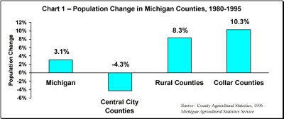
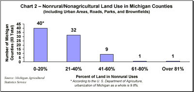
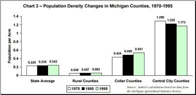
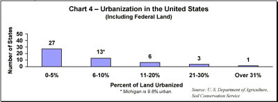
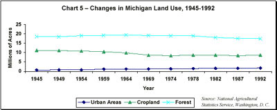
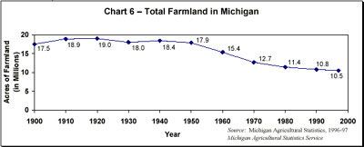
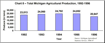
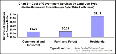
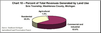
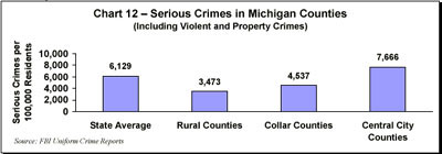
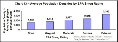