“We lose 10 acres of farmland an hour to development.”
— Gov. Jennifer Granholm
“The sprawl issue is more acute in the ‘90s than it was in the ‘80s.”
— Gov. John Engler
Alarm over land use is rooted in the popular misconception that forestland and farmland are fast disappearing as residential and commercial development overtake the landscape. In this section, we present the facts about land use in Michigan.
By every measure, Michigan remains largely a rural state. More than 18 million of Michigan’s 36 million acres is forestland,[8] a share that has actually grown by 2 million acres in the past 20 years. The amount of urbanized area (as defined by the U.S. Census Bureau[9]) comprises less than 10 percent of the state.
Even assuming a doubling of urbanized area over the next two decades, the Michigan Association of Home Builders has calculated that Michigan would still feature more non-urbanized land than 16 states, including Pennsylvania, Ohio, Tennessee, Virginia, New Jersey and Massachusetts.
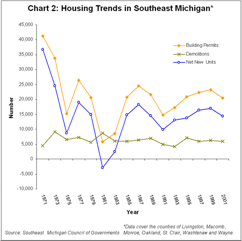
The current rate of development across the state is actually slower than in decades past. In the seven-county Southeast region of Michigan, for example, the number of housing permits – a standard proxy for development – peaked more than 30 years ago. In 1971, there were 41,228 new permits issued compared to 20,424 in 2001. When taking demolitions into account, a net total of 36,706 units were permitted in 1971 compared to 14,409 in 2001.[10]
The most significant residential shift actually occurred between 1900 and 1930, when the proportion of Michigan residents in rural communities dropped by half. The ratio of city dwellers to rural residents has changed only slightly in the years since.
Metropolitan areas (as defined by the U.S. Census Bureau[11]) now comprise 27.8 percent of the state, and two-thirds of the land even in these areas remains largely undeveloped. Yet Michigan’s population has grown from 2.4 million in 1900 to 9.9 million in 2000.
Our perceptions of uncontrolled growth and the loss of open space appear to stem more from the cumulative impact of two centuries of development rather than from any modern surge of “sprawl.”
There are fewer farms in Michigan today. In 1920, for example, there were 196,447 farms totaling about 19 million acres of land, compared to 46,027 farms with a land area of 10.4 million acres in 1997.[12] The average size of Michigan farms has increased from less than 100 acres to more than 200 acres.
The largest decline actually occurred between 1940 and 1970, with the conversion of 106,000 farms and more than 6 million acres. This post-war transformation was fueled, in part, by rising incomes and automobility, as well as by tax incentives for home ownership and by subsidized highway and sewer construction. Concurrently, a “green revolution” in agriculture and global trade reduced demand for cropland and pasture.
The rate of farmland loss has since slowed considerably. From 1990 to 1997, for example, 2,000 Michigan farms totaling 300,000 acres were converted to forest and park lands as well as to housing. In most instances, farmers idle the least productive cropland, which reduces the environmental impact of herbicides, fertilizers and other intensive treatments.
Conventional wisdom holds that most farmland is lost to residential and commercial development. In fact, 75 percent of farmland is converted to forestland or parks, wildlife areas or hunting preserves, while only 25 percent of the conversions involve development.
Even with 45 percent less land devoted to crops today as in the 1920s, agricultural yields have reached record highs. Farmers are growing far more food on much less land. In 1925, for example, farmers harvested 13 bushels of soybeans per acre, on average, compared to 36 bushels per acre in 2000. The yield of corn for feed grain likewise increased, from 39 bushels per acre in 1925 to 130 bushels per acre in 1999. Michigan dairy farmers, meanwhile, averaged 4,990 pounds of milk per cow annually in 1925 compared to 19,017 pounds per cow per year by 2000.[13]
Nor are continued farmland conversions likely to impact the food supply. According to the Economic Research Service of the U.S. Department of Agriculture: “Urbanization and the increase in rural residences do not threaten the U.S. cropland base or the level of agricultural production at present or in the near term. Urbanization rates of increase are relatively small and other land (such as forest, pasture, and range) can be shifted into crop production.”[14]
The single largest landholder in Michigan is government, which controls 28 percent of all property in the state. The Michigan Department of Natural Resources (DNR) controls 4.5 million acres, or 12 percent of the total land area. This sizable inventory ranks Michigan as 7th nationwide in the percentage of state-controlled land. The DNR also manages surface or mineral rights on 5.9 million acres of land as well the mineral rights to 24 million acres of Great Lakes bottomlands.
Chart 5: DNR Administered Lands
Program
|
|
Acres
|
|
State
Forest Lands |
|
3,866,266 |
|
State
Wildlife Areas |
|
300,300 |
|
State
Park & Recreation Areas |
|
259,969 |
|
Water
Access Sites |
|
27,961 |
|
Other
Department Land |
|
17,697 |
Source: Michigan Department of Natural Resources
In addition to DNR lands, The Michigan Department of Transportation controls 180,000 acres, and the Department of Military Affairs manages another 155,000 acres.
The federal government controls 3.1 million acres, or 8 percent of the total state land area, while local units of government control 114,000 acres, largely for recreation.
There are significant economic consequences to such large government land inventories. Unlike private property owners who have to pay property taxes, the DNR remits a heavily discounted “payment in lieu of taxes” (PILT) to counties and local governments. The amount of this annual payment is based on how the agency obtained the land.
By statute, all lands purchased, gifted or tax-reverted to the state prior to 1933 are assessed at a nominal $2 an acre. Those acquired after 1933 are assessed as agricultural land by the State Tax Commission – regardless of location or use. The DNR’s lands are also exempt from all special assessments, as well as from 18 of the 24 mills of school taxes.
Numerous counties in which large blocks of state land are located depend heavily on these PILT payments, discounted though they are. Thus, legislators and local officials were stunned in June by the agency’s announcement that it did not intend to pay the $150 million owed to locals for state-controlled lands.
Any private landowner unable to pay his or her taxes would be forced either to sell the property or face forfeiture. But in spite of the shortfall, DNR officials actually authorized at least $16 million worth of new land acquisitions. It is the unparalleled power of the state to ignore debt and, at the same time, increase spending.
The Legislature subsequently appropriated additional funds to cover the debt. But the PILT crisis demonstrates one of the risks inherent in government land control.